Share
This case study outlines how Barrow-in-Furness Borough Council has combined the use of open source software with the power of their Local Land and Property Gazetteer (LLPG) to meet local service delivery and EU regulations commitments all while saving money.
Background
Barrow-in-Furness is a mainly urban authority in Cumbria, North West England. It has a population of 70,700 people according to 2010 population estimates. The Directive on INfrastructure for SPatial InfoRmation in Europe (INSPIRE) is an EU legislation that aims to create a cross-boundary spatial data infrastructure. The Inspire regulations will have some impact on the local sector and the Local Government Association provides an excellent source of further information.
The problems
There were three main problems facing the council, which are common amongst many types of council. These include:
1. lack of resources and funding. The project featured in this case study began in 2009 and this constraint has become even more critical in subsequent years
2. ensuring compliance with legislative requirements of the EU Inspire regulation within tight financial constraints.
3. they had a further business requirement in that they did have existing propriety software which provided external web mapping services, this needed to be upgraded but they didn’t have the funds to do this. They also required web mapping functionality internally which required investment which would also not have been available.
The solution
The solution has been to deliver an agile web mapping solution using open source software. It utilises Barrow’s local gazetteer at its core to drive much of the functionality. It meets business needs, internally and customer facing while also meeting the Inspire requirements.
The web mapping service has been created in house and only uses open source software. The data is stored in an Oracle database internally and externally in Oracle XE, Oracle's free database. This is the only element of the system that is not open source. Oracle was chosen as the authority already had a site licence. Neighbouring authorities have implemented the system making use of Postgres/PostGIS an open source database.
The team knew that a cost efficient software solution was required to meet the needs listed in the previous section but also within the constraints of reduced budgets. The GI and Information officer gathered quotes for the cost of upgrading their existing software. At the same time, a testbed was developed as an example of a web mapping solution using open source software.
The GI and Information officer then presented the two options to Management. They decided that it was pertinent to pursue the open source route.
The GI and Information officer did have a strong interest in computer programming but no formal experience. This didn’t prevent the plans from going ahead though and with the help and support of the IT manager and his staff and a steep learning curve, the web mapping solution was delivered internally and externally in its first incarnation within three months.
Behind the scenes, a central Oracle database contains all the datasets used by the council, underpinned by the LLPG which provides the unique key to link all the datasets together and to enable the creation of new information on the fly. This is then linked to various systems using open source software and also supports the web mapping service.
The web mapping makes heavy use of the gazetteer, in both the public facing and staff facing environments. Not only does the Unique Property Reference Number (UPRN) help to join data together so staff gain an all-round view of a particular record through its address, the software also uses the cross references and historic property information and makes this available to those who require it.
Outcomes and impact
The web mapping solution has met each of the key requirements, within current constraints. Referring to section three above;
- cost – no direct cost, only staff time but this would have been required in any case
- meet Inspire regulations – this has been achieved for now and for the future. Key to the system also is that because it is agile and has been built in house, it can be changed relatively quickly and also for free. This is vital to future proof the systems
- internal requirements - the web mapping solution is now used extensively both internally and externally. It is used by managers and also by Members too.
The team make use of social media to communicate changes and updates to the system. They have a Facebook page and a Twitter page which they use to tweet about new information added and also to gather feedback from users and also a Tumblr link.
They also provide an “app” which users can download to their android phones and use to report a problem on the go. The gazetteer is integral to the “app” to ensure that accurate information is passed back to the council. This has been possible because of the open source software, it hasn’t required a heavy financial investment.
The system has received a good deal of coverage. The Local Government Association have published a case study of the same project which can be viewed here.
Furthermore, two neighbouring authorities have become so interested in the solution, they are now using it as part of their service.
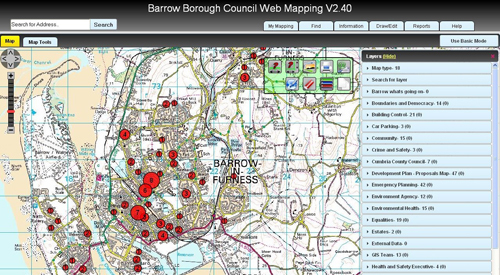
The following image shows data being loaded from the external system which holds a UPRN against each record. This is then used to map data and show the data as clusters.
Next steps
The team have some exciting plans for the next steps in the web mapping evolution. These include:
- looking at including three dimensional maps in the systems
- connecting more and more data from internal systems, using the gazetteer to link the information together intelligently
- enhancing on the fly analysis
- other enhancements as they emerge as requirements from the Inspire regulations
Key lessons from the project:
- don’t be scared of using open source and trying to do things yourself
- anyone can give it a go with their existing systems - have a play and see if you like it
- there is a lot of community support for open source software, you aren’t on your own
- it is surprising how may big organisations are using the same setup – if it is good enough for them it’s good enough for us
- the legislation offered a driver for change – this helped when making the case to management
- use the most appropriate tool for the job. Propriety software is still valuable to the council in some instances but they take a pick and mix approach and have found that most suppliers support this