Click here or on the image above to download a high quality version of the infographic
Blog
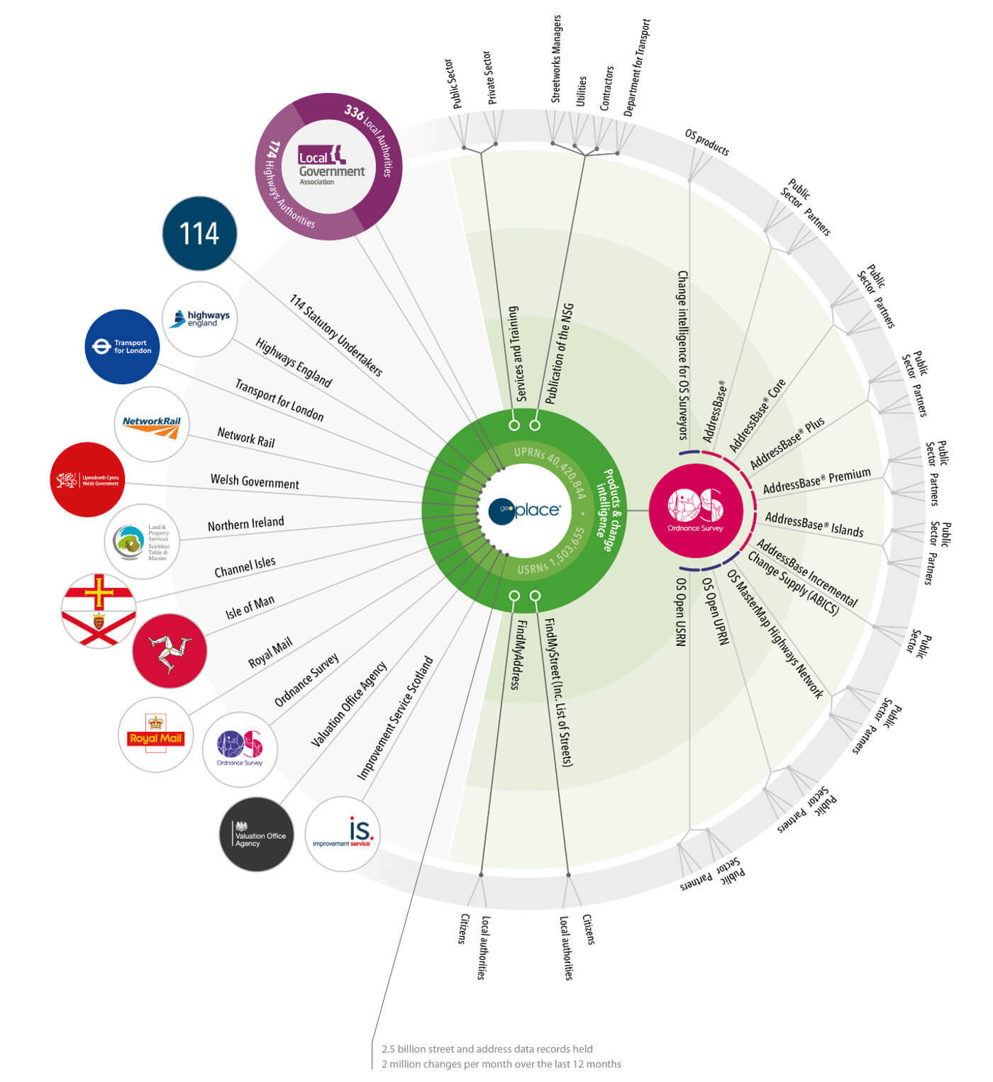
Building a data community
GeoPlace LLP has first-hand experience in creating communities based on a common interest in data, where members can amplify the impact of their work. This does not happen by accident - it can only happen with a deliberate and coordinated approach to community building.

Partnership working
GeoPlace partners with several organisations. Find out more about some of them below.
Section
Local Government Association (LGA)
The Local Government Association (LGA) is a politically led, cross-party national membership body for local authorities. Its core membership comprises 339 English councils and 22 Welsh councils through the Welsh Local Government Association.
Links
www.local.gov.uk
Section
Ordnance Survey (OS)
Ordnance Survey (OS) is Great Britain's national mapping agency. It carries out the official surveying of GB, providing the most accurate and up-to-date geographic data, which is relied on by government, business and individuals.
Links
www.ordnancesurvey.co.ukSection
JAG(UK)
JAG(UK) represents the best interests of every Highway and Road Authority in the United Kingdom. We have a Memorandum of Understanding with JAG(UK), enabling support that provides advice and support to the government through the Highway Authorities and Utilities Committee, and via direct contact with government departments.
Links
www.jaguk.org
Section
HAUC(UK)
HAUC(UK) brings highway authorities, utilities and government together with the aim of working safely and smartly to reduce the impact of street and road works on members of the public throughout the UK. We coordinate our work with HAUC(UK) through the JAG(UK) partnership. We run HAUC(UK) annual conference on their behalf, and manage their website and the HAUC app. We also project manage projects such as the Road to Net Zero. See more about HAUC(UK) here.
Links
www.hauc-uk.org.ukSection
National Underground Asset Register (NUAR)
The GeoPlace team provides valuable insight from the street works sector across highway authorities and utilities, helping to steer policy and developing best practice. As part of the wider NUAR delivery team, led by Ordnance Survey, they manage local authority onboarding and adoption in England and Wales.