Share
Welsh Government is using data-driven processes to inform planning and policymaking to support vulnerable people across Wales. To be effective, a multi-agency approach is essential for agility and speed of response. But how do multiple sets of information from multiple organisations link-up to ensure that the most vulnerable get the right support? Getting data protection and information governance right from the outset makes this challenge easier for local public services.
One example of nation-wide data sharing comes from Wales and the JISGO project. We spoke to Tony Bracey, Head of Programmes at Welsh Government to understand more about the data sharing challenges. Firstly, here is some background to JIGSO.
What is JIGSO?
The Joint Emergency Services Group Wales (JESG) has worked with GeoPlace, Ordnance Survey, and the Welsh local authorities and wider resilience community on a pilot scheme known as JIGSO (‘jigsaw’, in Welsh), see our previous case study on JIGSO.
Initially, JIGSO used Unique Property Reference Numbers (UPRNs) to develop data links between the Adult Social Services Departments in Mid and West Wales, and the local emergency services teams. This enabled the region’s fire and rescue service to carry out more effective home safety checks, particularly for the most vulnerable in our communities. In the second phase of the scheme, JIGSO incorporated data from other sources such as the Priority Services Register from Dwr Cymru (Welsh Water).
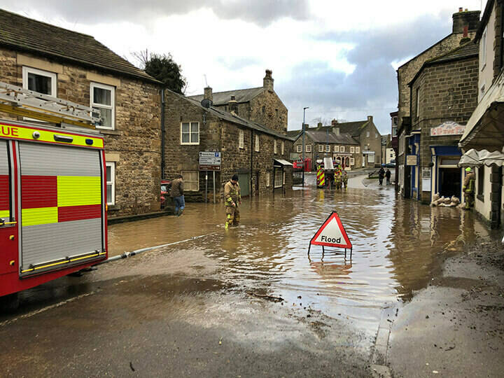
In essence, JIGSO enables Wales’s core non-personalised datasets to be made available to the resilience community, as a free to use service. All households that are known to be ‘at risk’ are pre-processed allowing teams in different areas to work collaboratively, instantly seeing which and how many properties are affected by risk factors. For example, identifying households and locations at risk of flooding, such as hospitals and care homes so that priority responses can be co-ordinated.
This is not a new system or a new piece of technology. It’s a process that optimises UPRNs, and hinges on the ‘create once, use many times’ principle to reduce the time it takes to get key information to responders. The integration of location data at this granular level means that for the resilience community, there’s now a means to plan and respond to any major incident in a far more objective way, resulting in greatly improved outcomes for citizens.
DataMapWales
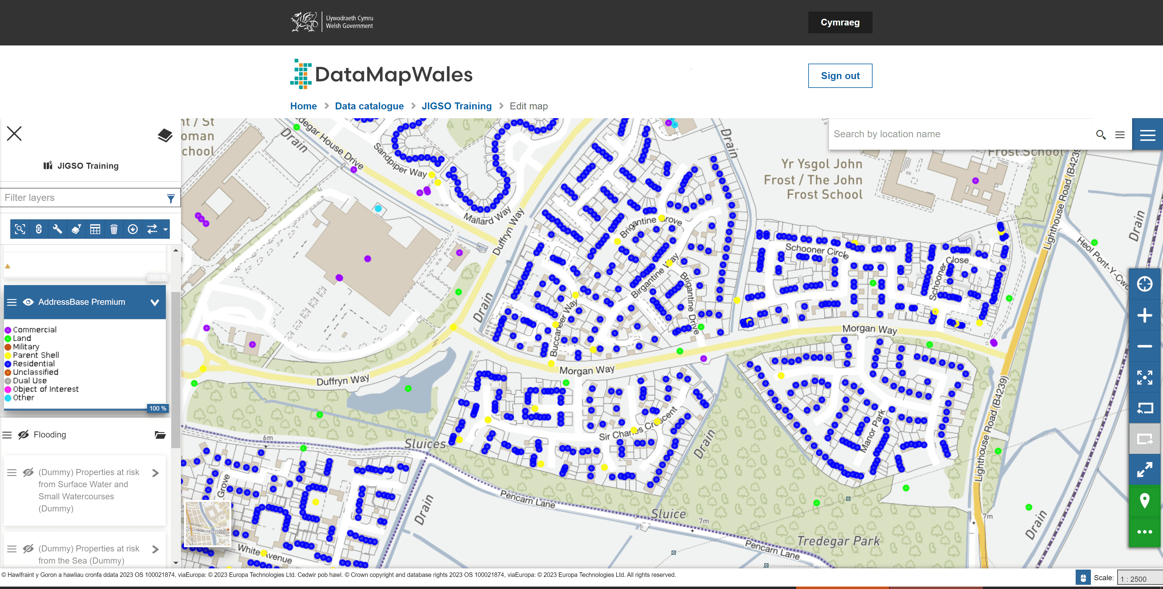
Emergency responders in Wales can utilise JIGSO data through DataMapWales, ensuring access to the most current data to prioritise responses in emergency situations. DataMapWales is a geospatial platform, serving as a source for public sector data in Wales. It has been used to make decisions extensively during the pandemic, for example, in identifying the most suitable locations for fixed and mobile vaccination centres using population data and drive times.
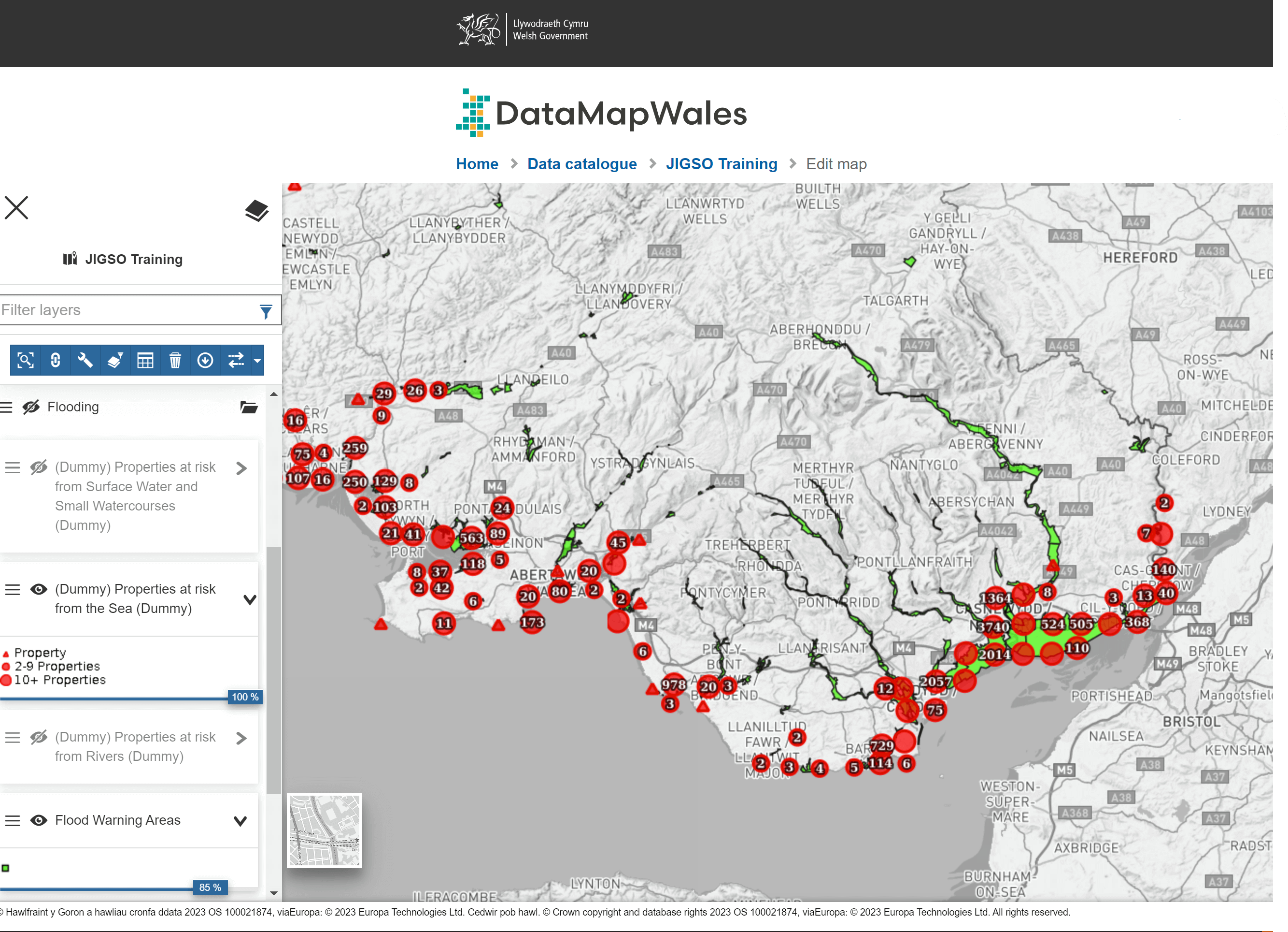
It is being used by local authorities in Wales to consult on active travel plans, bringing together a Wales-wide view of proposals for the first time. DataMapWales is also being used as part of a service (JIGSO) to provide the Welsh emergency responder community with up-to-date information to help them prioritise responses in emergency situations.
JIGSO project lead, Tony Bracey said: “The data came into its own during the second phase of the pilot scheme. The Dyfed Powys resilience team set out to identify all the vulnerable properties in the area ahead of any potential major incidents. When it comes to protecting the most vulnerable people in our society, the emergency services often go above and beyond. The incorporation of the UPRN into core business processes has delivered another major efficiency: streamlining the information-sharing process itself.”
JIGSO in detail
We asked Tony Bracey (TB) some in-depth questions about how JIGSO is used, what datasets are contained and how vulnerability is defined. Read our interview below.
Q1: Which organisations use the data from JIGSO and for what specific purpose(s)? Local authority social care, national health, integrated health, fire, police, ambulance, utilities?
TB: The four Local Resilience Forums across Wales which consist of Cat 1 and 2 Responders. The coordination activities tend to be organised differently so those we have currently provided ‘super user’ training to varies. However, at the moment it’s predominantly local authorities and emergency services. NHS health boards are supportive but due to operational pressures they are yet to become full users, the lead organisations during an emergency are usually the emergency services or local authorities. I am confident that this will change as the solution becomes more ‘business as usual’. Dwr Cymru have been trained and it’s their data we are using, they are keen to develop more robust scenario planning around reservoir breaches and other scenarios in the new year. The Coal Authority (due to spoil tips) have received awareness training and is going through the Cat 2 accreditation process. Only yesterday I received a request from one of the Mountain Rescue agencies to have access and hope to engage with them over the coming weeks to develop a suitable Use-Case to allow them access.
Q2: How do you define vulnerability? E.g. age, health, accessing benefits, living alone?
TB: We currently use the Dwr Cymru Priority Services Register (PSR). I’ve lectured enough on the inability of agencies not to be able to agree on vulnerability so I made the decision to use it and not been challenged to date (although I would love some form of definition). There is a ‘gap’ in mid Wales and I’m working with Severn Trent Water to get their data also which will provide us with all Wales water priority services register coverage. Next are Western Power and SSE but we wanted to get the Dwr Cymru data embedded first.
I am in discussion with the UK National Fire Chiefs Council around using either this list or a subset with regard several of their projects around identifying properties for a prioritised response in different scenarios. It’s quite broad and relies on ‘self-register’ which introduces an element of ‘gap’. I’ve received an email from one agency recently relating to the sharing of Dialysis information. We need further discussions but this would be a game changer for the JIGSO service across Wales.
I have also had conversations with Ordnance Survey who are collaborating with NHS England over identification of vulnerability using NHS Data e.g., GP registered over 65’s, the ‘Essex’ list, to see if this can also be incorporated. I have been asked about financial vulnerability, but I’m concerned if we start moving the goalposts too soon, we’ll lose the momentum.
Q3: Which specific datasets are shared and who are they sourced from?
TB: Dwr Cymru PSR is shared with the local resilience forums and Cat 1 and 2 Responders. We ask them to register with Gov Gateway to set up their account (we have to ‘whitelist’ approved agencies against which all access permissions are verified) of agencies and then we provide access using their Gov Gateway ID. Access can be restricted to individuals, agencies or groups and is layer specific e.g. PSR, spoil tips, wildfires etc.
Q4:Under what legislation/powers is the data shared?
TB: Article 6 of UK GDPR: Public task: the processing is necessary for you to perform a task in the public interest or for your official functions, and the task or function has a clear basis in law. A copy of our DSA is attached.
Q5: How are UPRNs added? At source? Centrally
TB: Dwr Cymru use UPRNs. We run a ‘sense check’ and inform them if their data requires amendment. The work we did with utilities during Covid-19 enhanced our knowledge and understanding of the UPRN. The other utility companies have either fully embedded UPRNs or are working towards doing so. This means that data can be easily linked.
Q6: How is the data shared? E.g. is it a text file, spreadsheet, API, via email, secure file transfer etc
TB: The data is electronically shared via secure automated file sharing We use APIs, also for example the Natural Resources Wales flood alert system uses an API that updates every 30mins which was invaluable during last year’s flooding. Teams were able to draw down data based on the latest alerts and be ahead of the game.
We already have the defibrillator data in JIGSO, we engaged with Welsh Ambulance Service which uses a system called the Circuit, which is also powered by UPRNs, in collaboration with the British Heart Foundation. We will soon be investigating how we can use JIGSO to allow WAST to update guardian data also.
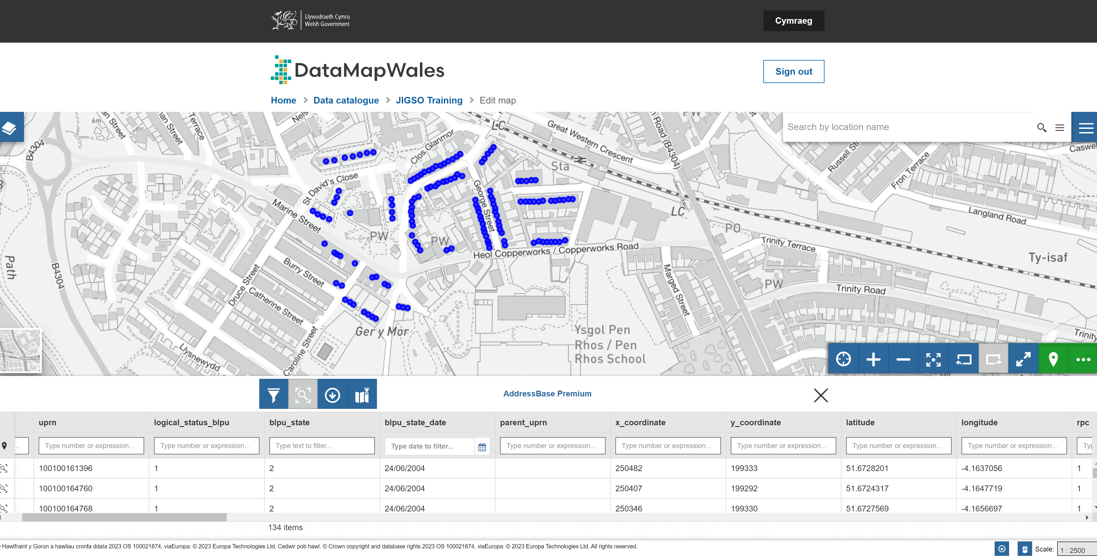
Q7: How does the end user interact with it? Eg BI tool, GIS map, Data Map Wales?
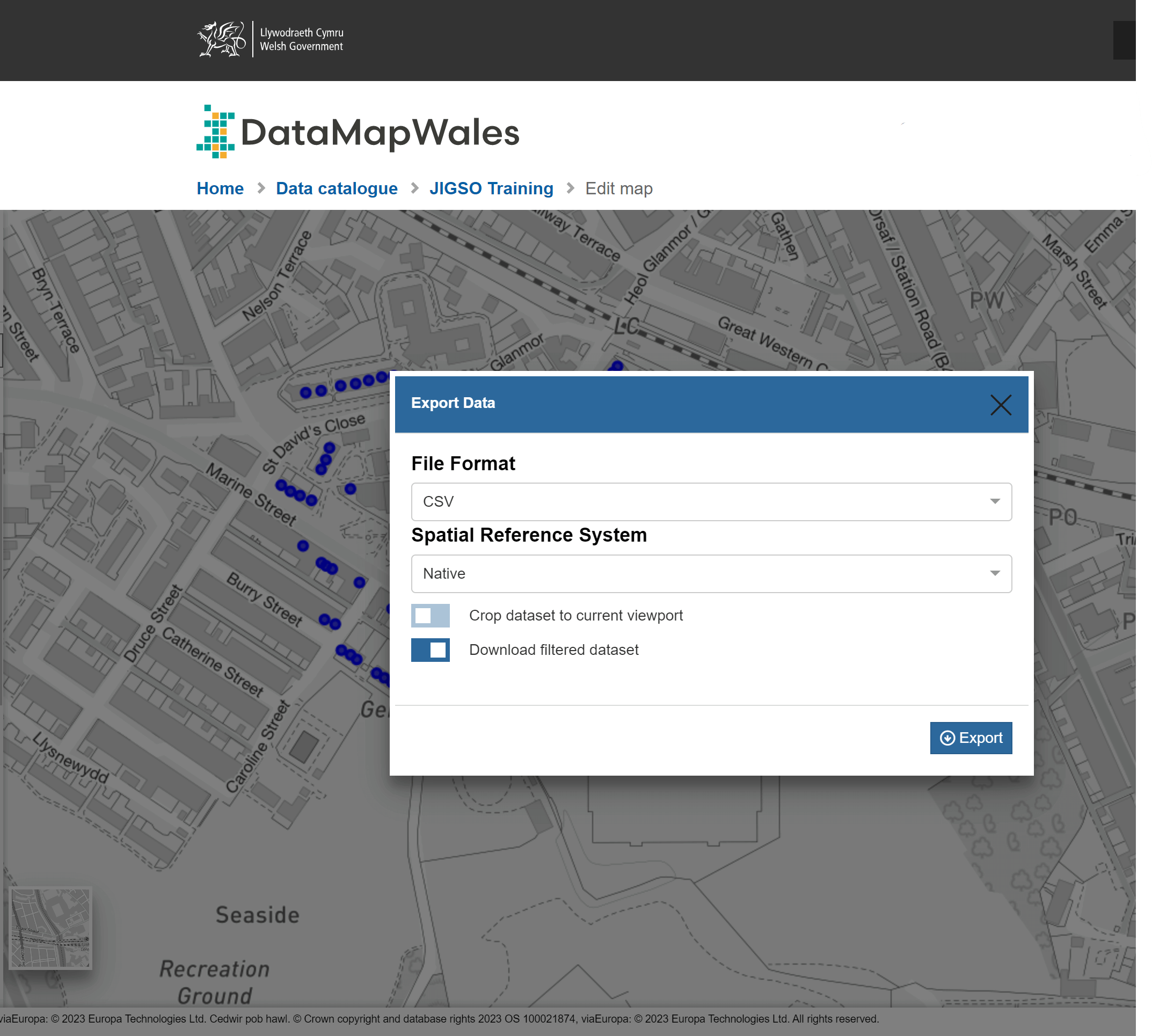
TB: Users access the information via the JIGSO web service from mobile devices which sits on DataMapWales. Think of JIGSO as being the secure area of the publicly accessible DataMapWales website which I think has over 2,000 layers. So, for example, a user can draw a polygon and download the PSR properties within that area and share it as we know in less than three minutes. In fact, during Storm Eunice, I was able to achieve less than 60 seconds in some instances. The conversation with the NFCC is that they have a very good Power BI tool but no way of simply presenting that data to users. They are keen to explore the use of JIGSO as the user front end to the Power BI analytical processes. End users can also download the data in web/GIS format if they want to upload the data into their own systems.