

Share
Linking people and places - case study from the Joint Emergency Services Group Wales (JESG) for GeoPlace Exemplar Awards 2018
The UK’s emergency services deliver exceptional support under the challenging circumstances. In almost every aspect of their work, a first response to risk involves pin-pointing a location – and the Unique Property Reference Number (UPRN) can play a huge part in responding more effectively to critical events.
Forward-thinking organisations understand the value of using location data to analyse an environment. In the UK, the emergency services offer life-saving support 24-hours a day and the UPRN can be a vital tool in their preparations.
A UPRN is assigned to every man-made property in Great Britain at the start of the planning process. Because this identifier remains constant throughout the lifecycle of a building until the property is demolished, the UPRN can provide a unique guarantee of interoperability. The location of a property offers the certainty of a link from and to many other, disparate sources of information that might held by different organisations, perhaps even in different formats.
As a unique data point, the UPRN enables the sharing of personal information without the identity of the individuals concerned being revealed. This means that individual organisations (such as the emergency services, the police, social services, and not for profit agencies), can work together more efficiently, while at the same reducing the risk to beneficiaries – ‘vulnerable individuals’ in particular.
Linking people via places
For many organisations, the identification of vulnerable individuals is a pre-requisite for their business models. Utility providers, in particular, have a statutory duty of care towards people who may find it harder to access or pay for their services, or who need essential services to ensure their health and wellbeing. Someone may need a mains-powered oxygen concentrator, for example, to aid their breathing. A family might be reliant on an emergency medical alarm, or find some forms of communication less appropriate for their needs.
In the past, the emergency services have tried to capture and combine that vital data about vulnerable individuals’ locations from different sources. This approach can lead to errors with room for doubt over the most up-to-date, single version of the truth. By the same token, the same data may in fact be stored and worked on by multiple agencies, which again might lead to trust issues. What’s needed is a means of connecting those datasets with a robust, single, unique point of reference.
UPRNs: planning to save lives
The Joint Emergency Services Group Wales (JESG) worked with GeoPlace LLP, Ordnance Survey, and the Welsh local authorities on a pilot scheme known as JIGSO (‘jigsaw’, in Welsh) – using UPRNS to collate information about individuals’ vulnerability on an address-by-address basis.
A number of agencies in Wales had been holding property-based information in siloed databases, identifying the locations of vulnerable individuals.
Initially, the scheme used UPRNS to develop data links between the adult social services’ departments in Mid and West Wales, and the local emergency services teams. This enabled the region’s fire and rescue service to carry out more effective fire safety checks in the home. In a second phase of the scheme, however, JESG incorporated data from other sources such as Welsh Water and Western Power Distribution.
JESG project lead, Tony Bracey: “The data came into its own during the second phase of the pilot scheme. The Dyfed Powys resilience team set out to identify all the vulnerable properties in the area ahead of any potential major incidents.
When it comes to protecting the most vulnerable people in our society, the emergency services often go above and beyond. The incorporation of the UPRN into core business processes has delivered another major efficiency: streamlining the information-sharing process itself.
“The resilience community in Wales meets on a regular basis to discuss their preparedness for potential major incidents,” said Bracey. “Part of that InCab devices link to UPRNs GeoPlace is a public sector limited liability partnership between the Local Government Association and Ordnance Survey GeoPlace 157-197 Buckingham Palace Road London · SW1W 9SP · T. 020 7630 4600 · www.geoplace.co.uk process involves passing information to the senior commander on scene – who’ll will be relying on us to deliver data accurately, with certainty, about vulnerable people that might be affected most in an emergency situation, and they’re located.
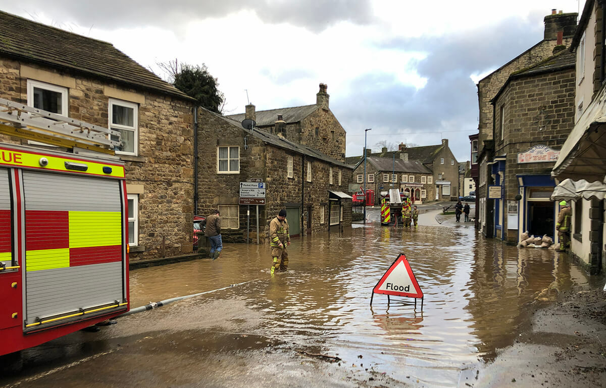
Using the UPRN, and with the information we can see via the Cabinet Office’s Resilience Direct online mapping service, it’s far easier for us to access and use the right information at the right time. We can overlay predictions about, for example, flooding in a particular area as well as the different types of properties, potential evacuation areas and so on.”
Resilience Direct
The Resilience Direct platform is an online, private ‘network’ of information that enables civil protection practitioners to work together, in real time. Via the platform, many agencies can collate and cross-reference information across geographical and organizational boundaries during the preparation, response and recovery phases of an event or emergency.
Resilience Direct is made accessible through what the government calls the ‘standard internet’, and populated with location data using the UPRN to identify properties at individual building level. Currently, Resilience Direct is used to raise awareness of resilience exercises; to share emergency plans among local resilience forum members, and to support the government’s immediate situation reports and briefings (such as COBRa meetings, in Whitehall).

