Share
By Steve Brandwood, Executive Director of Engagement, GeoPlace.

Cover image, The Council House, College Green, Bristol. This property was given the first UPRN in the National Land and Property Gazeteer, UPRN 1.
With the recent announcement of the Geospatial Commission’s Strategy, a new Public Sector Geospatial Agreement in place, Open UPRN and USRN products now available, a mandate on Central Government and NHS bodies to adopt UPRNs and USRNs and the introduction of AddressBase Core, a new lower price point AddressBase product released into the market, it feels like this moment is a significant step-change in the delivery of a national geospatial framework.
Our vision at GeoPlace is a world in which everyone benefits from the power of location data and our mission in this is to excel in delivering street and addressing data that inspires innovation and transforms people's lives. This is a long-held ambition for us that can be tracked back over 50 years.
There have been several other significant moments in this story that we thought would be worth noting as we celebrate our most recent achievements. Our history is a shared history and our achievements are shared with our local authority Custodian colleagues, and the various organisations that share our vision and supported our mission over the years.
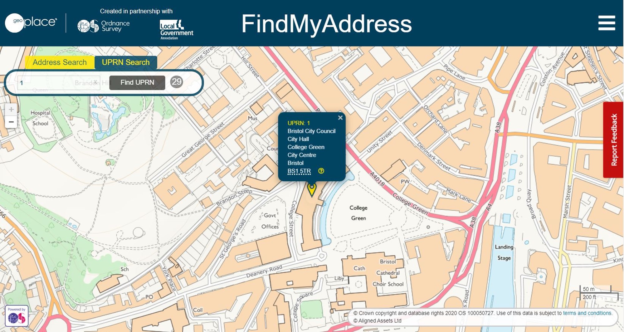
Image of UPRN '1' taken from FindMyStreet
Our approach has been to work in partnership towards a common goal, not just in providing a focal point for the collation of data but acting as an interface between local government and central government and other users of the data. The successes we jointly celebrate today are as a direct result of the support, engagement, perseverance, and frankly hard work from across our stakeholders and partners.
As we mark a significant milestone, it’s important we recognise and say thank you to everyone working with us to improve peoples lives through first class location data.
GeoPlace, as a partnership between the Local Government Association and Ordnance Survey, has been in place since 2011 when the then Secretary of State for Communities and Local Government, the Rt Hon Lord Pickles, called for the creators and suppliers of addressing data to come together to build a single national address database.
But the history of standardisation of address and street data goes back as far as the 1970/80s as GeoPlace’s MD Nick Chapallaz writes in his recent blog.
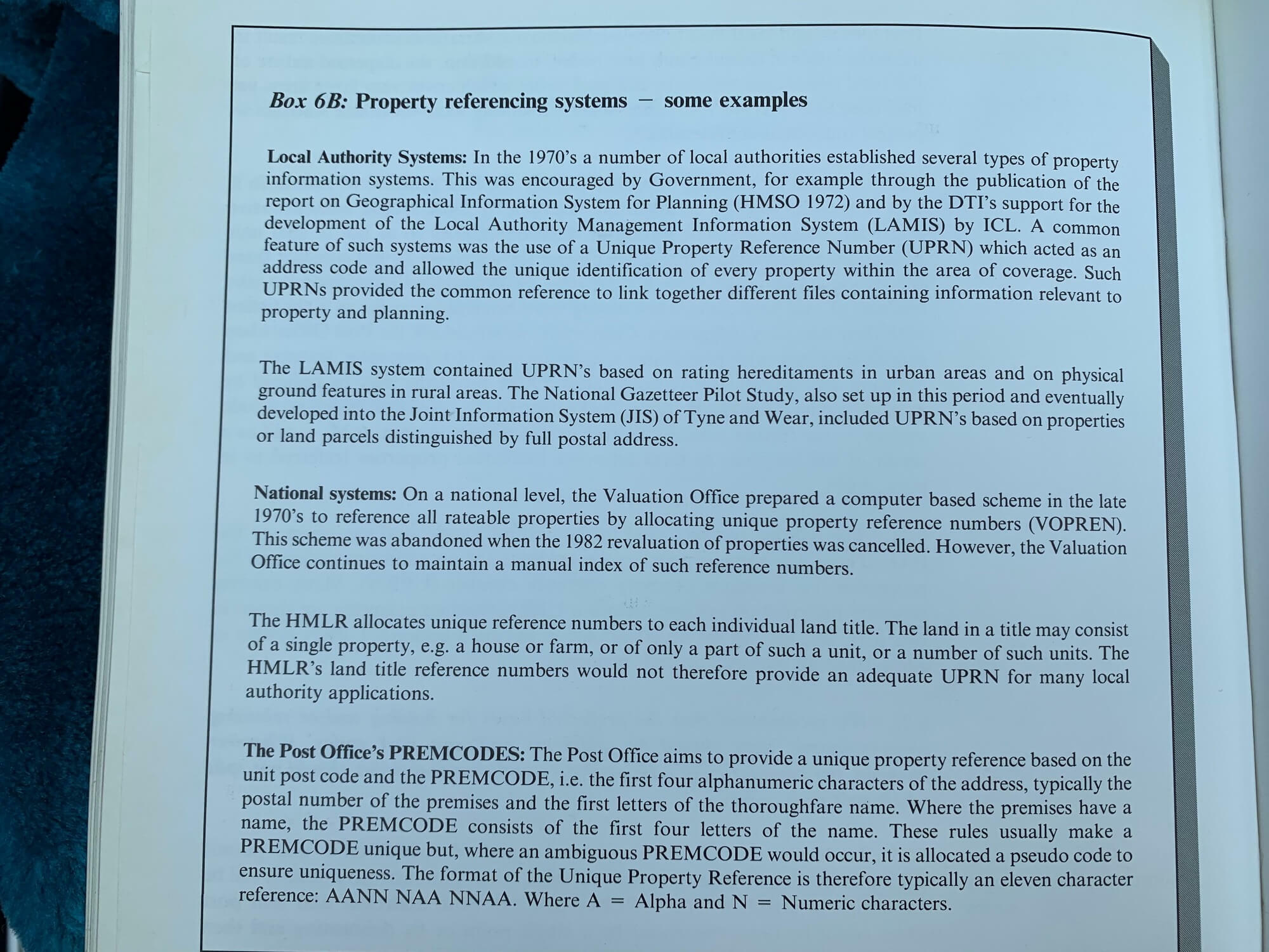
Extract from 'Handling Geographic Information - Report of the Committee of Enquiry chaired by Lord Chorley'.
My involvement began in 1998 as part of a small team lead by Dr Andrew Larner working in the Local Government Management Board (LGMB) which latterly became the Improvement and Development Agency for Local Government (IDeA) – part of the Local Government Association group of organisations. This team came together to further information management in local government by consolidating thinking across the sector and driving best practice.
I joined at the point 10 years after the landmark ‘Chorley Report’ was published. The Chorley Report examined and made recommendations on the potential of GIS to improve analysis and decision making. The report specifically discussed and recommended the use of spatial identifiers to bring data together and, along with the report triggering the creation of the Association for Geographic Information, it lead to the development of the British Standard BS7666 – Spatial Datasets for Geographic Referencing.
A number of local authorities, including Bristol, Newcastle, Devon and others, were trailblazing the use of GIS and realised quickly that properly managed, definitive spatially referenced data was needed at the heart of geospatial analysis and that geographic information was at the heart of local service delivery.
The development of BS7666 was very much driven by local government as there was a clear and recognised need to standardise core geographic referenced data as over 80% of local government services relied on this. Standardisation and attribution of unique references numbers provided a platform for better information management and better service delivery.
The creation of BS7666 was a key milestone.
Lead by Andrew Larner, and prior to that Tony Black, the LGMB team published best practice and encouraged take up of BS7666 in local government. It also developed a single mapping agreement between OS and local government – a precursor to the PSGA as we see it today. Around 1998, the LGMB became the IDeA and my job was to push forward with a national rollout programme to create BS7666 Local Land and Property Gazetteers and Local Street Gazetteers in local authorities. At the same time, we signed an agreement with OS to collate these gazetteers centrally and take these to market.
For various reasons this partnership between local government and OS fell apart shortly after, although OS remained National Street Gazetteer custodian until 2005 when Intelligent Addressing took over the Custodianship .
By 2000, local government interest and commitment to standardise address and street data grown significantly and there were a number of real world applications that were calling for the model we were pushing – including NLIS (online conveyancing), emergency service use and joining services across local authority boundaries).
At this time government was driving a programme of e-Government and standardised address and street data was positioned as a core building block under a local/central Information Age Concordat.
There was also significant interest from the private sector. As a result, a new partnership was formed between local government and Intelligent Addressing (IA), a private sector firm lead by Michael Nicholson that had a great deal of experience of BS7666 (in the form of Nick Griffiths and Simon Barlow – also both now GeoPlace Exec Directors) as IA had implemented the standard to manage and market commercial property information.
IA provided the technical infrastructure and the IDeA (the team developed a subsidiary to take the initiative forward – the Local Government Information House (LGIH)) contracted with every local authority to create, maintain and provide LLPGs and LSGs centrally for publication.

This partnership hit another important milestone in the early 2000’s by successfully bringing all local authorities together in this shared service to create and regularly maintain the National Land and Property Gazetteer and National Street Gazetteer. However, with OS also investing in AddressPoint and subsequently AddressLayer, competition in the market lead to what has been referred to as ‘the address wars’.
Over that 10 year period, there was significant investment by local authorities in the quality, consistency, timeliness and adoption of the data. So much so, that by 2010, government was asking for OS and local government to come together to maintain a single set of definitive data for the new Public Sector Mapping Agreement. This milestone was achieved by bringing together IA, LGIH (the LGA) and OS into a joint venture – GeoPlace.
Another 10 years on and we are now celebrating the recognition that the data we have been collectively maintaining for 20 years is now a key cornerstone of the Geospatial Commission’s Strategy; adoption across public and private sectors is exponentially growing with a further massive advance expected as a result of the GDS mandate and a growth into the market from a lower price point product; and the release of the UPRN and USRN as open data means that we are moving considerably closer to the ubiquitous use of these IDs.
All these things support the vision that has its roots in the Chorley Report and many of us have championed for many years.
As I said at the start of this piece, none of this would have been possible without the support and dedication of everyone involved – whether an ‘old-timer’ or a ‘newbie’. I think we can look forward over the next 10 years to achieving further milestones in the knowledge that the original vision has truly stood the test of time.