Share
The Census passes in a moment, but its impact is felt for over a decade. In our role at the heart of Britain’s addressing system, GeoPlace has been instrumental in ensuring the Office for National Statistics (ONS) has the right addressing data to run the 2021 Census.
Since 1801, the nation has been setting aside one day every ten years to conduct the census, collecting an understanding of all people and households. It is the most complete source of information about the population we have, and it’s the information that’s used to help define government strategy and make policy decisions (in both the public and private sector), which affect all of our lives. It is estimated that local authorities will derive around £1.8 billion of value from the 2021 Census over the next 10 years; analysing their areas in detail to accurately determine the level of support needed from central government.
Households living at every recorded address are asked to take part, and that means there’s a need to build the mechanism that runs the Census with an authoritative view of all addressing – using the most current data possible. This year, the Census will be using an address list that’s based on Ordnance Survey’s AddressBase Premium product, and made available by Ordnance Survey through the Public Sector Geospatial Agreement (PSGA).
This is a step-change in methodology, as the previous Census was delivered by using an isolated register of people’s addresses, which the ONS created themselves. Now, however, the value of tapping into the single most up to date and accurate data source has now been realised – but it’s the interoperability of other systems that will benefit from this new approach.
“Councils depend on the Census for their income. That income is what pays for citizen-services, so it’s imperative that every citizen is included. GeoPlace’s work has been pivotal in underpinning the method by which we will all benefit from the 2021 Census.” Nick Chapallaz, Managing Director
By using AddressBase, the ONS is ensuring not only the quality, timeliness and suitability of underlying information, but is also creating a dataset that can be integrated more easily with disparate systems that will want to use the Census’ results. With the Unique Property Reference Number (UPRN) included in the development of the Address dataset, the 2021 Census will be incredibly valuable when it comes to surfacing and then using those referenced demographics in analysis and decision-making.
It’s important to understand the role of the UPRN here. Its value is rooted in its ability to underpin detailed, complex information pools anonymously. The ONS’s outputs are ideal for statistical research purposes: they enable the government to analyse needs at a macro level, and other organisations to undertake multivariate statistical work at a micro level without needing to worry about using personal data.

Over the past three years, we’ve been working closely both with ONS and the local authorities to ensure AddressBase Premium is as up to date as possible, notably on the data associated with communal establishments; tertiary level residential classifications; and student hall accommodation. UPRNs make it possible for the ‘households’ within a college, for example, to be included as individual records. Over the course of the three years, there has been a 29% improvement in residential records being classified to a tertiary level (ie. detached dwelling) to just over 97%.
“The Address Index team at ONS have continued our close working relationship with GeoPlace to ensure the list of residential addresses for Census 2021 was the highest possible quality. As a result we have been able to share best practice for improving the data and we have avoided duplication of effort. We have jointly created guidance for local authorities for improving their address lists to meet Census needs. During the live Census operation we will be using the most up-to-date information available to us through our arrangement with GeoPlace so that we can ensure Census forms reach any new and changed addresses.” Charlie Dacke, Head of Address Index in Data Architecture, Office for National Statistics.
It is this partnership between the ONS, GeoPlace, local authorities and Ordnance Survey that has provided the rigour into the resulting address data. Due to their statutory roles around planning and street naming and numbering, local authorities are the originators of addresses and property change intelligence. GeoPlace manages the central hub, taking feeds from every local authority to develop a consistent national dataset, which is now used by thousands of users right across the public and private sectors as well as the emergency services to support service delivery.
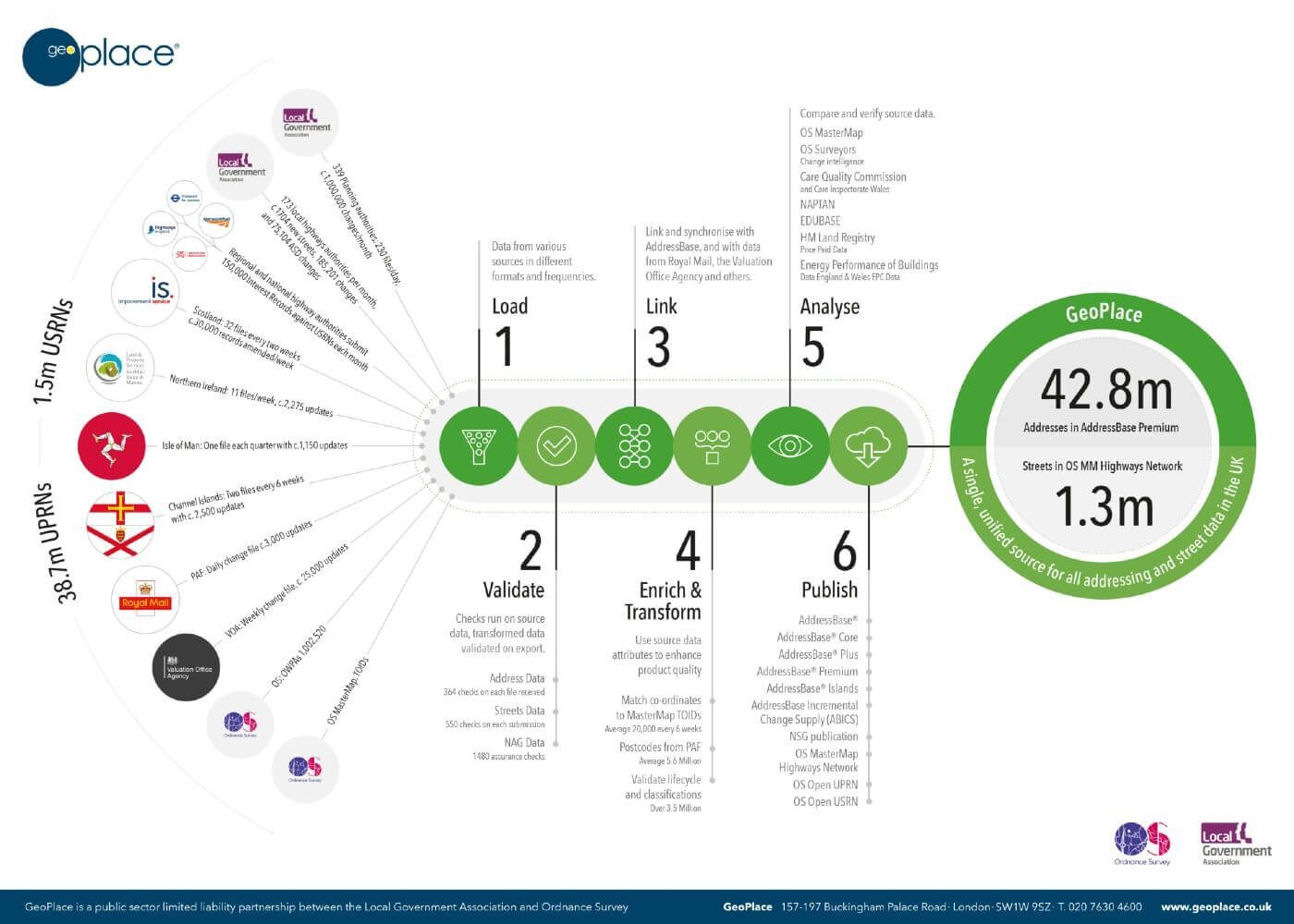
The infographic below illustrates the processes that take place at GeoPlace.
TO DOWNLOAD THIS GEOHUB INFOGRAPHIC - CLICK HERE
All of the resulting statistics and knowledge gained will help councils make better decisions for businesses and residents alike. The Census underpins a rigorous evidence base with which to take decisions on planning for infrastructure, transport, housing, education, social care, health and welfare and other front line service planning – and none of this would be possible without the use of high quality, up to date street and addressing data.
Find out more on how the 2021 Census has been addressed at https://www.geoplace.co.uk/local-authority-resources/guidance-for-custodians/how-to/census.