

Share
GeoPlace is working with central and devolved governments to include the UPRN in data sent to local authorities to support shielding measures for vulnerable people to COVID-19.
Utilising the UPRN will:
- enable segmentation and targeting of support
- help authorities to quickly and easily link to other sources including the social care system to help see who is vulnerable and already receiving social care
- enable data to be mapped and analysed spatially to look for trends
- see who is in areas of high deprivation and who has poor access to services
- provide standardised national data to central government for policy making.
The UPRN means this can happen in minutes, avoiding time consuming address matching exercises which drains resources, slows down the process and can lead to error. In the worst case the analysis and targeting of support could just not happen because it is too difficult to link the data.

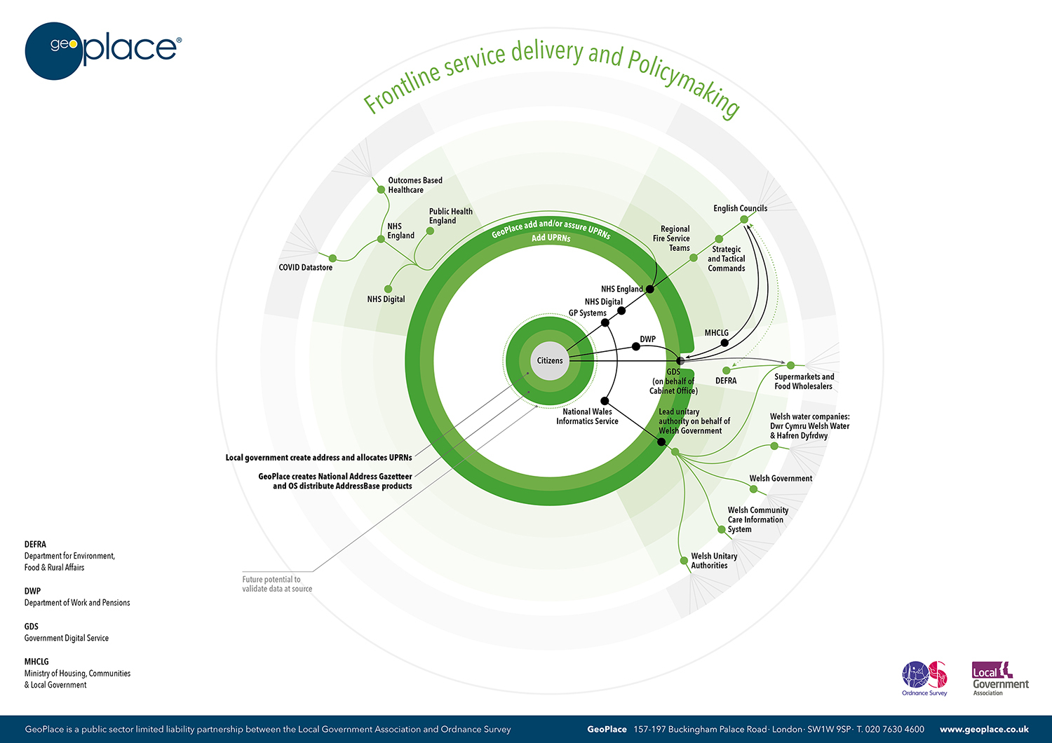
Data flow through government
GeoPlace has published a blog highlighting the absolute importance of the UPRN in responding to COVID-19.
When we know where people are, we can help them faster and we can help them better. Today, with COVID-19 affecting us all, we've never been more dependent on the ability of our health services, local and central government to deliver vital support measures and services exactly where they're needed most.
Critical resources must be managed efficiently. From policy-making managers to front-line key workers, everyone needs information they can trust to help keep us safe. But there's one simple, common question that has to be answered in every part of that complex process – where, exactly, should everything be happening?
GeoPlace sits at the heart of the community that's providing the answer. The Unique Property Reference Number (UPRN) is now open data, and it's embedded in critical responses to COVID-19. This is the story so far - blog.geo.place/2020/05/21/uprns-supporting-the-response-to-covid-19.
The infographic below shows the data flows through government, aided by the UPRN:
Local authorities are leading the way
Local authorities are leading the way in the area of data management and GeoPlace has written a number of articles highlighting the role of the UPRN in the response to COVID-19:
- Can we find answers to coronavirus questions in location data?
- UPRNs - supporting the response to Covid-19 (GeoPlace blog)
- How UPRNs can support the coronavirus response (UKA article)
- Local authorities are using UPRNs to provide support for vulnerable people
- Wales is using the UPRN to coordinate the COVID-19 response to the most vulnerable
- Bradford NHS team aims to extend data links for Covid-19 research
- COVID-19 - A Geographer’s Response.
In its work to support wider ‘at risk' groups, Welsh Government has identified those who are extremely vulnerable to COVID-19 as a consequence of an underlying health condition, and sent them a letter from the Chief Medical Officer asking them to shield themselves and ensure a package of support is available for those who need it.
Crucial in being able to meet this group's support needs has been providing the data on them securely to each of the local authorities in an integrated format that is most useable/helpful to them. GeoPlace has supported Welsh Government in this work, enabling them to share these complex and integrated data sets with local authorities.
Statement from the LGA
Coronavirus contact tracing at risk unless vital info shared with councils
The LGA have issued a statement saying that "Crucial data must be shared with councils to make use of their local knowledge and expertise and ensure vital national efforts to track and trace coronavirus succeed".
After listing the key sources of data needed by council, the statement continues "This data should also include unique property reference numbers (UPRNs), so that councils can identify hotspots, map where the virus is prevalent and plan for action. It will also enable councils to link the data up with their existing systems to fill important gaps in their information".
Read more at https://www.local.gov.uk/coronavirus-contact-tracing-risk-unless-vital-info-shared-councils.
UK Authority have published an article based on the LGA statement, read it at https://www.ukauthority.com/articles/lga-calls-for-councils-to-get-coronavirus-data/

GeoPlace support
GeoPlace is working with local authorities to support their work dealing with Essential Supplies to Shielded People.
Additionally, we are working with
- DEFRA – Essential Supplies coordination
- NHS England – addition of UPRN to patient records
- Public Health England – support with Care Homes Data
- Greater London Authority (Mayors Office) – business seeking rates relief locations across London
- Welsh Government – resolving address data issues and addition of UPRN
Nick Chapallaz, Managing Director of GeoPace is speaking at the UK Authority Powering Digital Public Services event on 15th May on ‘Bridging central and local government with UPRNs to respond to COVID-19'. The webinar is free to attend for the public sector.

Other resources
FindMyStreet
Our web service findmystreet.co.uk is helping authorities deal with highway search queries whilst they/public are unable to access paper records in council buildings. FindMyStreet tells you where a street is, what its official name is, & the maintenance responsibility of that street.
Data matching and COVID-19
In responding to the pandemic, we have seen the UPRN being used by the data analysts who create the insight, the policy makers who use the business intelligence, the managers who target resources and the people on the front line delivering public services to those that need them most.
If you need help with matching data to addresses for your response to COVID-19 contact GeoPlace at [email protected].
Welsh Government
In its work to support wider ‘at risk' groups, Welsh Government has identified those who are extremely vulnerable to COVID-19 as a consequence of an underlying health condition, sent them a letter from the Chief Medical Officer asking them to shield themselves and ensure a package of support is available for those who need it.
Crucial in being able to meet this group's support needs has been providing the data on them securely to each of the local authorities in an integrated format that is most useable/helpful to them. GeoPlace has supported Welsh Government in this work, enabling them to share these complex and integrated data sets with local authorities.
JAG(UK) and the streetworks community
Working with the Department for Transport, Scottish and Welsh Governments, HAUC(UK) and Street Works UK, JAG(UK has published advice and guidance to authorities and practitioners around streetworks and the impact of COVID-19. See https://www.jaguk.org/news/covid-19-guidance for the guidance.
Traffic Management Act 2004: network management in response to COVID-19
The Department for Transport has issued additional statutory guidance issued by the Secretary of State for Transport under Section 18 of the Traffic Management Act 2004 ("the act"). It applies to all highway authorities in England, who shall have regard to this guidance to deliver their network management duty under the act.
It does not replace the original Network Management Duty Guidance published in November 2004, but provides additional advice on techniques for managing roads to deal with COVID-19 response related issues. It will be reviewed 3 months after publication.
The guidance sets out high-level principles to help local authorities to manage their roads and what actions they should take. Updates to this document or further guidance on related subjects may be published as the need is identified.
Additional announcements from the DfT are available at:
- £2 billion package to create new era for cycling and walking - https://www.gov.uk/government/news/2-billion-package-to-create-new-era-for-cycling-and-walking
- Transport Secretary's statement on coronavirus (COVID-19): 9 May 2020 - https://www.gov.uk/government/speeches/transport-secretarys-statement-on-coronavirus-covid-19-9-may-2020.

