Share
In December 2024, GeoPlace responded to an Invitation to Tender (ITT) from Durham County Council to develop a lane rental scheme (LRS) that would enhance management of its highway network.
Awarded the contract in February 2025, GeoPlace collaborated with the council to prepare a Statutory Instrument (SI) for submission to the Department for Transport (DfT) by 1st October 2025, with an aim of DfT approval in January 2026.
The scheme targets County Durham’s roads, aiming to reduce the congestion caused by road and street works, while at the same time incentivising utility companies and contractors to schedule works at less disruptive times or locations and work jointly with other organisations.
Lane rental allows a highway authority to charge up to £2,500 per day for works on the busiest roads at the busiest times. It helps to minimise disruption and charges apply to works promoted by both utility companies and highway authorities.

The scenario: reducing congestion on County Durham’s roads
County Durham’s highway network serves a large population of over 530,000 individuals, and supports residents, businesses, and visitors. Particularly during peak hours, roadworks can cause delays, which can impact economic activity and public satisfaction.
The council wanted to implement a lane rental scheme, charging works promoters for occupying the busiest streets at peak times. The aspiration was to encourage early engagement to reduce the impact of road and street works through better ways of working which could include off-peak scheduling, joint works, or alternative locations. The goal was to identify a suitable lane rental network, ensure compliance with DfT requirements as set out in ‘Lane rental scheme: guidance for English Highway Authorities 2024’, and develop a financially sustainable scheme that would maximise the benefits for all road users, while at the same time integrating smoothly with County Durham’s existing permit scheme.
The solution: GeoPlace’s data-driven approach
Drawing from its hands-on experience and expertise in permit scheme evaluations and lane rental implementations since 2015, GeoPlace partnered with JAG(UK) and GK-TC to design a robust LRS using a structured methodology:
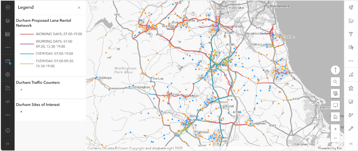
- network identification: GeoPlace’s Critical Highway Routes Identification Service (CHRIS) tool integrates DfT datasets, traffic flow data, and road and street works data to pinpoint the busier roads in County Durham’s network. A traffic sensitive street review, combined with knowledge from the council’s highways team, refined the selection to ensure the scheme targeted high-impact routes
- feasibility analysis: GeoPlace produced a comprehensive LRS feasibility report, assessing operating costs, staffing needs, and potential fee income. The report proposed lane rental models with cost banding and time restrictions tailored to County Durham’s needs, ensuring cost neutrality and value for money
- cost-benefit analysis: At a time when budgets are tight, cost-benefit analysis is crucial. A DfT-compliant report outlined the scheme’s financial and societal benefits, including reduced congestion and improved road user experience. “The Lane Rental Scheme gives us new powers to ensure roadworks are delivered more quickly and efficiently. That means fewer delays, reduced disruption, and better journeys for everyone” said Cllr Tim McGuinness, Cabinet member for Rural, Farming and Transport at Durham County Council
- stakeholder engagement: GeoPlace developed a multi-level communication plan, which included an ARC GIS web map, MS Excel outputs of Unique Street Reference Numbers (USRNs), and a variety of presentations for stakeholders – ensuring everyone involved understood the benefits of this proposed scheme. Preceded by informal discussions, the proposed Lane Rental Network went through a 6-week formal consultation process, ensuring there were plenty of opportunities for all stakeholders to voice informed opinions. Luke Meaton, Streetworks Operations & Regulatory Manager at Openreach noted, “This collaborative approach gives us confidence that the scheme will work effectively for all stakeholders”.
- statutory instrument submission: the council submitted the LRS Statutory Instrument to the DfT, incorporating consultation outcomes and a robust evidence base.
The results: a foundation for smarter road management
GeoPlace’s collaboration has provided a data-driven, DfT-compliant lane rental scheme proposal, setting the stage for implementation pending approval in January 2026. Key outcomes include:
- Targeted network identification: Approximately 163 miles of County Durham’s busiest roads have been identified for lane rental charges, with an informed focus on peak-hour congestion hotspots
- Projected impact: The feasibility study estimates there will be a 70% reduction in peak-hour roadworks within the first year. Based on comparable schemes, this will potentially transfer 4,500 days of works into less congested periods every year
- Financial sustainability: The cost-benefit analysis confirmed significant operational benefits and cost neutrality, with projected fee income covering operational costs, aligning with DfT requirements
- Improved coordination: The scheme is expected to increase collaborative working among works promoters by 100%, streamlining their permit applications and reducing network disruption overall.
Conclusion: a model for highway efficiency
GeoPlace has developed a forward-thinking lane rental scheme that promises to enhance road network efficiency and collaboration, while at the same time prioritising public benefit.
It’s a balancing act, and GeoPlace’s experience has ensured a well-communicated articulation of the proposal, and its benefits, to the wider community. GeoPlace’s proven methodology offers a scalable blueprint for local authorities seeking to implement lane rental schemes such as this one, demonstrating the power of data-driven solutions in modern road management.
Find out more about GeoPlace's lane rental scheme implementation here.