

Share
Oxfordshire County Council - Runner up: GeoPlace Exemplar Awards 2022

Introduction
FixMyStreet is a tool that lets users map and report street problems to the councils responsible for fixing them. This includes potholes, broken streetlamps, dog fouling and issues with fencing.
Oxfordshire County Council has integrated FixMyStreet with the National Street Gazetteer (NSG), which means more detailed data can be provided to those dealing and responding to street problems. The main reason for linking these two systems was to make it easier to communicate clearly with customers.
This case study looks at the work done by Oxfordshire County Council, and explains the benefits realised by Oxfordshire by linking citizen report portals with apps such as FixMyStreet with the NSG.
The Problem
Historically, Oxfordshire County Council realised it was duplicating a lot of the effort needed to maintain multiple datasets related to streets. It had multiple systems and databases. Each business area had their own applications which did not link to other systems or data. Data was held in hundreds of spreadsheets, multiple access databases, emails, paper maps / records, system bespoke databases, contractor systems and shared network drives with no consistent approach to using, retrieving, updating, and interpreting the data. This means that there wasn’t a single view on what was happening across the whole of the authority.
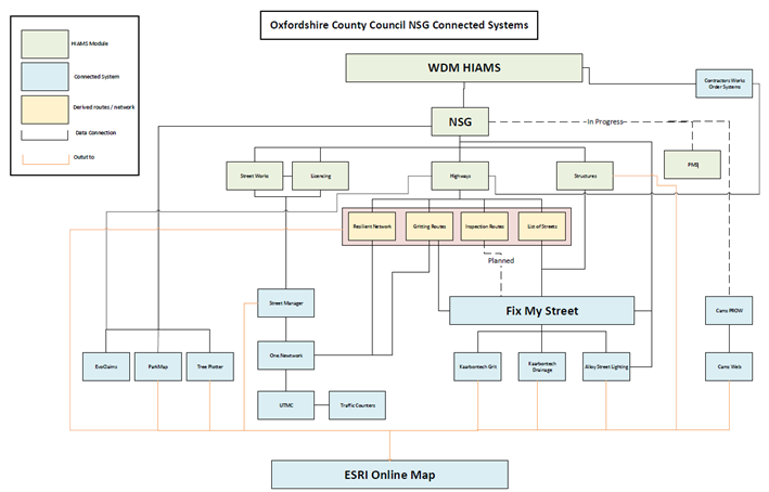
To overcome this the council used the NSG and specifically the USRN to provide a single thread of data to which all other council systems could connect. This data cleanse and integration linked the NSG with FixMyStreet.
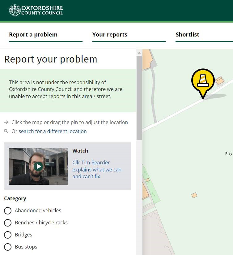
One of the main aims of integrating the NSG with FixMyStreet was to improve communications for users and improve the time it took to get a response after raising a query. One of the goals was to ensure that, once the NSG was incorporated, users could see if a street was maintained by the council or not. This in turn would reduce the number of calls the council received about private streets.
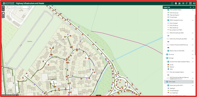
Oxfordshire County Council’s vision is to have a single source of street data and all systems linked to the Geographic Information System (GIS). The aim is to make it possible for searches, by USRN, to discover all the information available on a certain asset e.g., streetlighting.
The solution
A data cleanse was needed before linking FixMyStreet to the NSG, as the maintenance responsibility of every street needed to be accurate. Once complete, the council asked FixMyStreet to write a script of web feature services to be used.
The USRN has now been integrated into many systems in the council. When an enquiry comes into FixMyStreet, it automatically selects a USRN and logs the location and type of enquiry which is then passed onto the relevant inspector where it’s logged on their tablet. Any responses sent by the inspector automatically go back to FixMyStreet, as well as any relevant contractor systems. If the query is a defect, then the contractor system notifies FixMyStreet when the issue has been fixed and the customer is updated.
Specific attributes of the USRN are included the official street name element alongside the maintenance responsibility. The NSG is also used in managing defects in Oxfordshire. Where possible the USRN is attached to every asset and enquiry. Around 20% of enquires that come to the council are defects.
Using the NSG means that all of the streets related databases in the authority can be connected, giving a single view of the network.
The benefits and results
Knowing whether or not a street is maintained by Oxfordshire County Council has made a great improvement to FixMyStreet. Having this insight has massively changed the number of queries received by the council. By linking FixMyStreet to the USRN, the council can identify defects that are or aren’t their responsibly, and give customers this information at the first point of contact – whereas previously, the customers would have had to wait or be redirected to customer services. The council can now respond automatically. This has reduced enquires by around 5%. This has resulted in immense time savings.
The NSG has been linked the Claims Handling system. Now when a claim comes in on a highway issue, the system automatically searches using the USRN for all enquiries, defects, inspections etc. for the relevant information. In the past, this was a manual search. Now the system can automatically repudiate a claim automatically without any manual intervention from our claims team. This saves on average 30 minutes per claim.
Before incorporating the NSG, a customer would have had to wait up to two weeks for a response. Highway inspectors would have to go to the site to see whether it was privately owned or not before a response was given. As the NSG has allowed for information on private ownership to be added to FixMyStreet, customers can now have responses straight away.
Having the USRNs integrated has also saved time for inspectors. For example, one pothole can lead to many queries coming in. Incorporating the USRN has reduced repeat visits by providing the right details about ownership immediately, saving time for genuine enquires. Customers now have a clear response, and they can be redirected to resources that can help them resolve issues about privately owned streets or assets.
Going forward, Oxfordshire County Council plans to build on the work done to link FixMyStreet to the USRNs. One plan is to add highway extents, which would help customers to understand which bridges are or aren’t maintained by the county council. Another aim is to add Public Rights of Way (PROW) – so that any customers raising issues about PROW can be directed quickly to a page dedicated to those reports. Another plan is to include information on footways and cycle routes that are not maintained by the council.
Conclusion
By linking FixMyStreet to USRNs, Oxfordshire County Council has improved the quality of its communications with customers greatly. By using the NSG to connect all of the streets related systems, there is now a single source of data which is accessible to all staff and only editable by those who are responsible for its maintenance.
Here the council talks about reporting issues through FixMyStreet:
In this video, the council explains why some issues don’t meet the authority’s intervention threshold:
Any councils wanting to know more about the Oxfordshire approach can contact [email protected]

