

Integration reports
Below are examples of personalised integration reports and infographics that your authority recieve, plus a video introduction for a quick overview the integrations that can be powered using the UPRN and USRN.
Download
Example authority street data integration report 2025
This personalised, in-depth report is created from Annual Improvement Schedule Questionnaires and provides a clear overview of how well address data and the USRN are currently embedded across your authority, highlighting strengths, gaps, and trends over time.
Download
Example authority address data integration report 2025
This personalised, in-depth report is created from Annual Improvement Schedule Questionnaires and provides a clear overview of how well address data and the UPRN are currently embedded across your authority, highlighting strengths, gaps, and trends over time.
Download
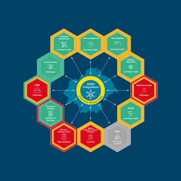
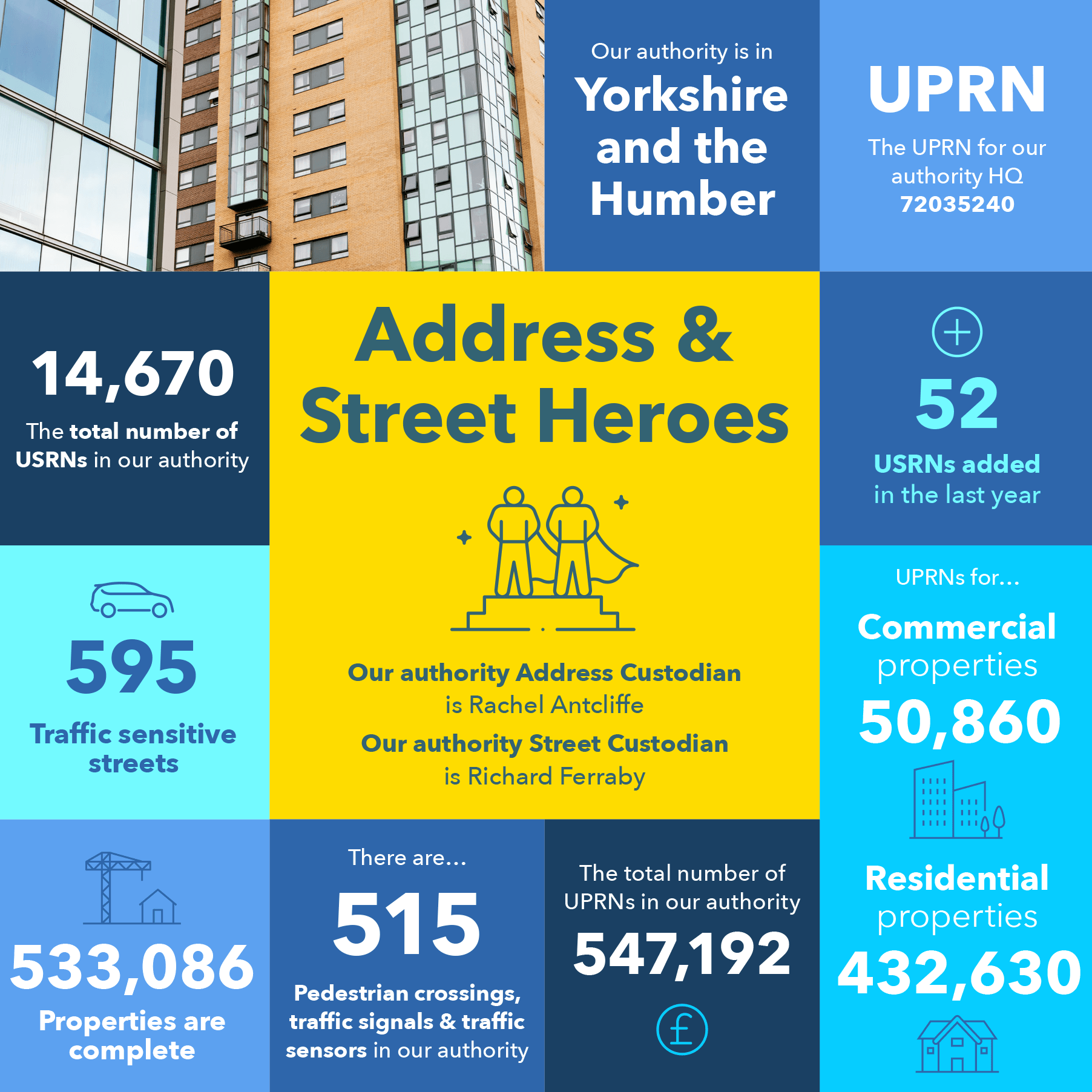
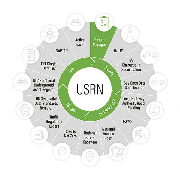
USRN integration snapshot - sample
This is a personalised infographic that provides a graphical 'snapshot' of USRN integration with key systems within your local authority. Here you can view an example of the infographic that has been sent direct to your Custodian.
Download
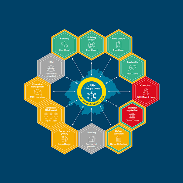
UPRN integration snapshot - sample
This is a personalised infographic that provides a graphical 'snapshot' of UPRN integration with key systems within your local authority. Here you can view an example of the infographic that has been sent direct to your Custodian.
Download
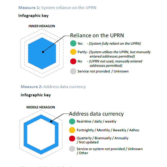
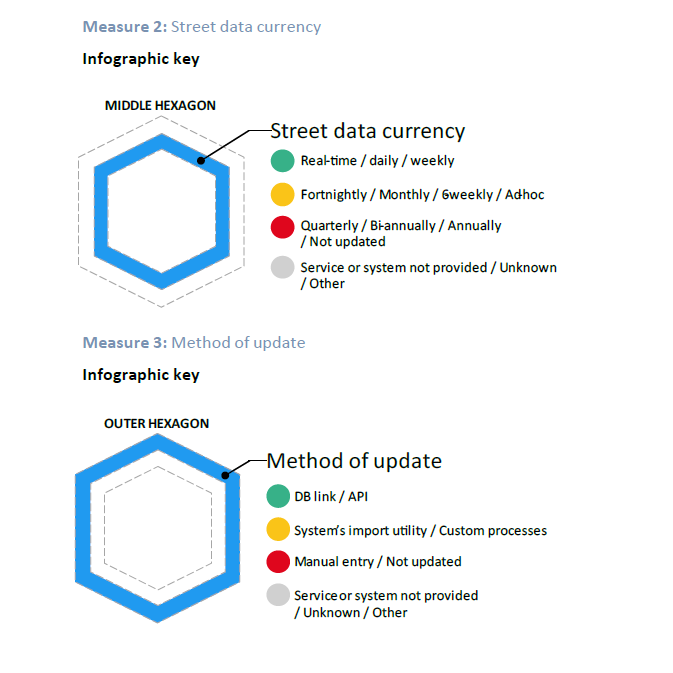
How the UPRN integration infographic was created
Here is an explanation about the UPRN integration infographic.
Download
How the USRN integration infographic was created
An explanation about the USRN integration infographic.
UPRNs and USRNs powering integration (animated infographic)
Find more integration resources here:
Your data
The value of integration
Integration is a way of unlocking value from those vast amounts of data you hold about people and places. GeoPlace has developed tools to enable officers to assess the maturity of integration within systems.

Visualising your gazetteer
Personalised infographics have been sent to your Address Custodian and Street Custodian. Below are examples of the infographics for your information. Contact [email protected] with any questions.
Download
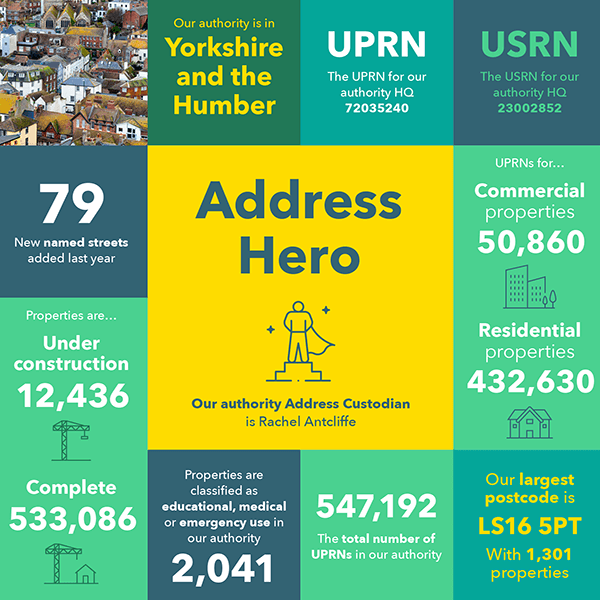
Your combined data infographic
We've created a personalised infographic illustrating the combined data in your LLPG and LSG. Here you can view an example of the infographic that is being sent direct to your Custodian (with thanks to Leeds City Council).
Download
Your LLPG data infographic - sample
We've created a personalised infographic illustrating the data in your LLPG. Here you can view an example of the infographic that is being sent direct to your Custodian (with thanks to Leeds City Council).
Download
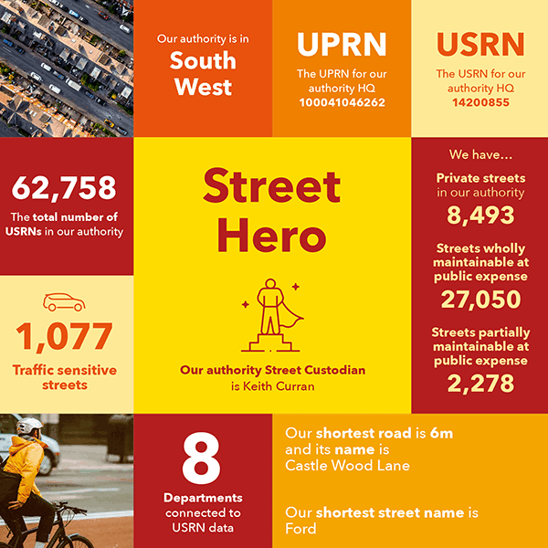
Your LSG data infographic - sample
We've created a personalised infographic illustrating the data in your LSG. Here you can view an example of the infographic that has been sent direct to your Custodian (with thanks to Devon County Council). FAQs about the infographic are found here.
General infographics
Download
Local2National
Local authority Custodians connect people with places, supporting public services, emergency response and businesses.
Download
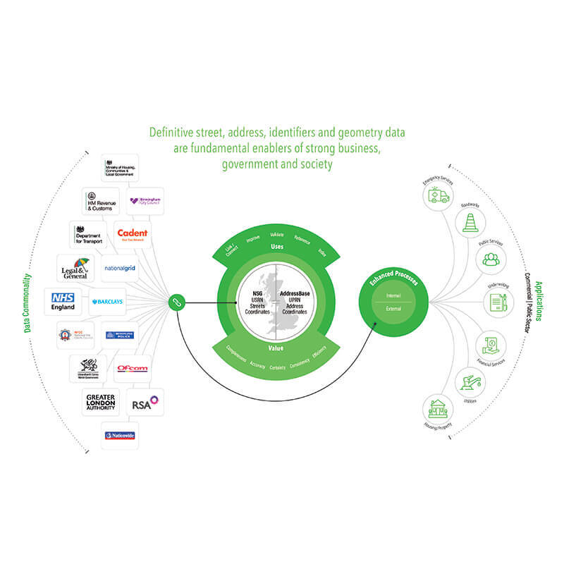
Data enabling business, government and society
Definitive street, address, identifiers and geometry data are fundamental enables of strong business, government and society. See the infographic here.
Download
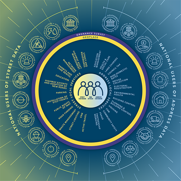
Relationships around the UPRN and USRN
Hundreds of organisations come together to feed into the national address and street datasets, and then use them. View the infographic here.
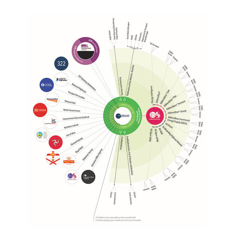
Find out more about the processes that take place at GeoPlace
Click on the image for a closer look.