Share
When any organisation marks ten years of growth, it is surely a time to celebrate its success. But as we look back on GeoPlace’s decade of achievement, we’re also looking forward, too.

GeoPlace sits at the heart of a community whose vision is a world where everyone benefits from the power of location information. Many of the people within our community have an enthusiasm for promoting the use of precise location that – literally – knows no bounds. We are populated by experts with a wealth of spatial knowledge. How to use location-data; how to make data accessible and interoperable; how to derive incredible benefits from integrating standardised location in ever-more diverse ways. Our mutual appetite for innovation and quality should stand us in good stead as we aim to deliver the value needed by a fast-changing world.
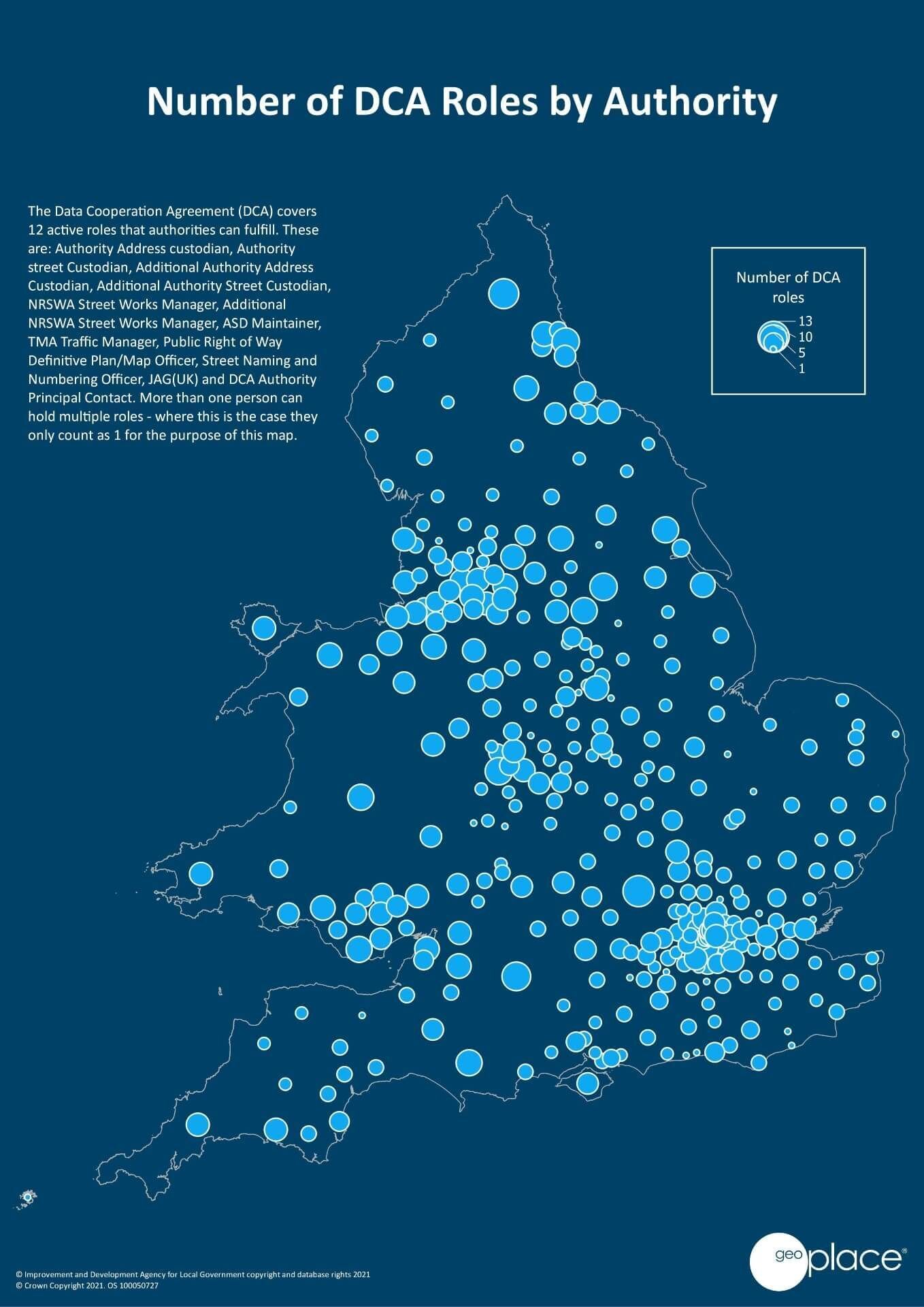
Hopefully, it won’t be seen as too self-congratulatory, but to be in this position now – working with 361 local authorities, and 554 partners involved in data collection and curation, supporting 437 individual Custodians to help us create the highest quality gazetteers possible – GeoPlace has made incredible progress in a relatively short space of time.
GeoPlace’s success reflects its partners’ hard work
We believe GeoPlace’s structure has been the catalyst for much of its success to date. We are a partnership – a collaboration between the Local Government Association and Ordnance Survey – and that partnership extends beyond our operations into our ethos, too. From the small team that started consolidating various ideas about standardising location, to the complex ecosystem of organisations that drives best practice today, we can all celebrate that the data we’ve been collectively maintaining has become the cornerstone of the Geospatial Commission’s Strategy.
Our successes are a direct result of the support, engagement, perseverance, and hard work that stakeholders and partners have delivered over the last decade. It’s true, we were building on strong foundations. However, in the space of a decade, we have put a national address and street infrastructure into place that’s seen now as an exemplar around the world.
A fast-paced trajectory of growth and achievement
It was ten years ago that the then Secretary of State for Communities and Local Government, the Rt Hon Lord Pickles, suggested that creators and suppliers of addressing data should collaborate on the construction of a single national address database. Even before 2011, the value of precise location had long been established. The landmark ‘Chorley Report’ had surfaced the potential for geographic information systems to improve analysis and decision making, and the need for a unified, standardised source of address and street data. The value of authoritative location information was indisputable, and the Chorley Report’s recommendations on the use of spatial identifiers still underpin our work today.
Health. Wealth. Commerce; culture; societal development, more accurate decision-making, and deeper understanding. Initially, Rt Hon Lord Pickles’ aspiration was the creation of ‘a national address book’ for the benefit of the emergency services. Today, that ‘address book’ (the National Address Gazetteer and AddressBase products) is making the difference and enabling the emergency services to save more lives in a global pandemic.
* See below for Key Statistics from maps/data
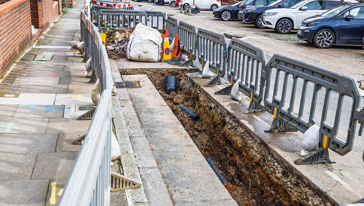
It’s not just the National Address Gazetteer that’s recognised internationally as the ‘best of the best’, our national streets data infrastructure is as well. Every local highway authority and every utility that has a right to ‘dig up the road’ uses the National Street Gazetteer (NSG) to manage essential immediate repairs, undertake routine maintenance and plan major upgrades. The NSG holds the essential information that is needed before starting works; the roads and streets that are traffic sensitive, that have engineering difficulties and roads with special surface. This enables better planning and co-ordination, minimising disruption to the travelling public and businesses that use the road network. Timely and accurate works data helps the public to avoid traffic hotspots, reduce congestion and emissions, and save time that might be otherwise wasted – thereby bringing value back into the economy.
* See below for Key Statistics from maps/data
Looking forward to the next ten years
We know that what we do matters. What we aim to achieve over the next ten years will be even more important: promoting wider adoption of the Unique Property Reference Number (UPRN) and Unique Street Reference Number (USRN) across the public and private sector is just the beginning. We’re proud of having helped to develop BS7666 – Spatial datasets for geographical referencing – the standard on which the local address and street gazetteers from local authorities and the national gazetteers are built, but our commitment to standards is future-facing: our work now involves helping myriad, diverse organisations to implement those standards, and to start putting the gazetteers and unique identifiers to best effect.
We’re a willing source of expertise – recognised as a Centre of Excellence, with consultancy added to our portfolio of services – and perhaps this is the moment to be celebrating our role at the heart of a vibrant community for many years to come.
Our approach has always been to work in partnership towards a common goal. With the Geospatial Commission’s Strategy, a new Public Sector Geospatial Agreement in place, Open UPRN and USRN products now available, a mandate on Central Government and NHS bodies to adopt UPRNs and USRNs, and the introduction of AddressBase Core … it’s becoming even easier for organisations with little or no experience in using location data to derive all the benefits and value it offers. We are a focal point for the collation of that data, but we are also as an interface between local government and central government and other users of location-information.
Our enthusiasm may know no bounds, but there are many organisations that aren’t aware of the potential savings, risk mitigations, more in-depth analysis, and better decisions that can be made by using location-date. There are inevitable changes in the nation’s infrastructure, which mean we’ll have to continually evolve our approach to promoting best practice. The property sector is undergoing changes that reflect shifts in society’s forthcoming needs; local authorities are becoming more consumer-centric and more sensitive to the requirements of vulnerable members of society; the climate crisis will have a transformative impact on transport and energy, and all of these sectors rely on our outputs to improve their efficiency and effectiveness.
However, those are all challenges we look forward to tackling head-on in the company of a close-knit community committed to delivering excellence in location-data. We’re thrilled to be celebrating a decade of achievement. Advances in all kinds of technology and approaches to data-management may have helped us bring ideas to fruition at scale and in real time, over the last ten years. And we haven’t lost our appetite for delivering best practice that lets us truly bring location to life.
NOTE:
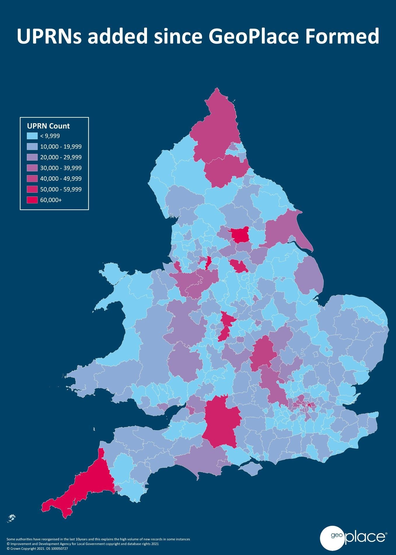
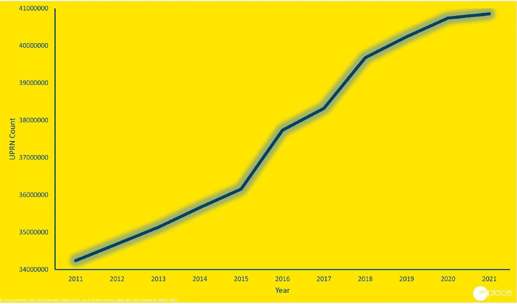
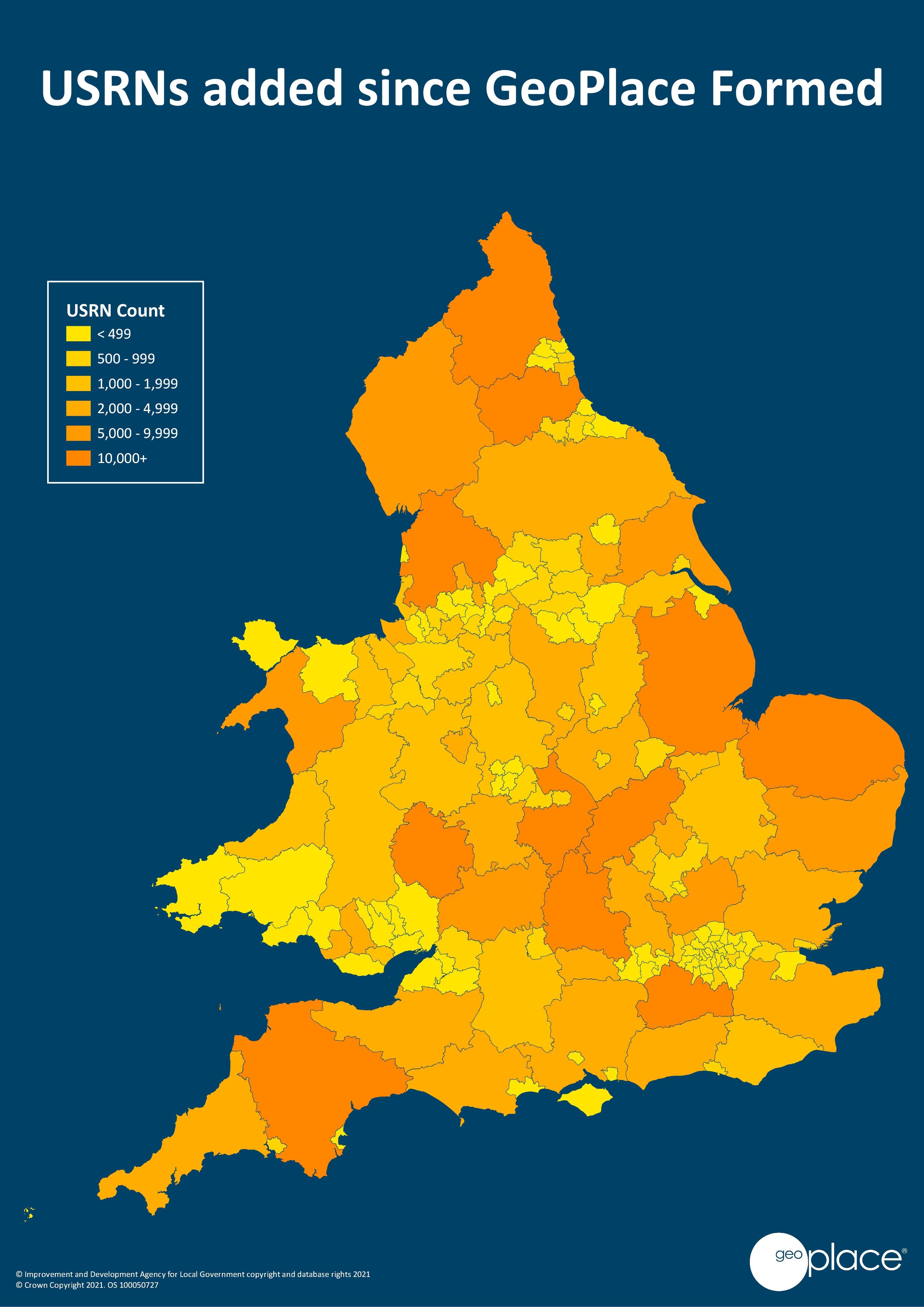
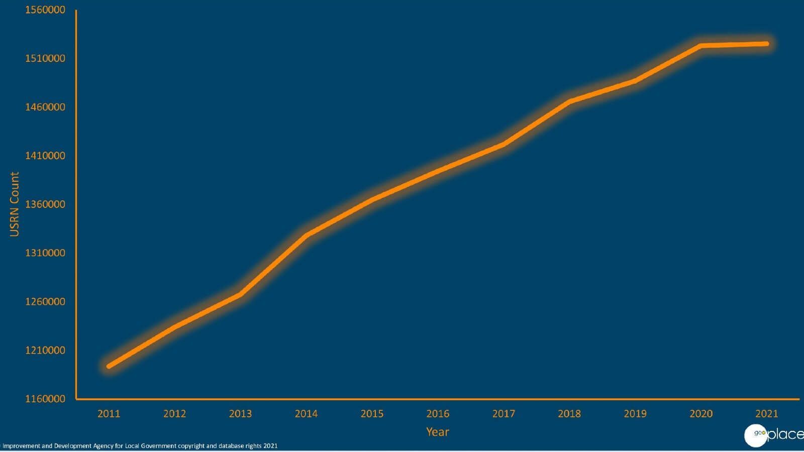
Key Statistics from maps/data:
- UPRN/USRN added map is only England and Wales.
- Greatest number of UPRNs added is Cornwall:69,910
- Greatest number of USRNs added is Durham: 23,675
- UPRN/USRN added graph is any authority that submits to GeoPlace i.e. includes Ireland, Scotland, Isle of Man, Jersey/Guernsey
- Over 6.8million UPRNs added into database in last 10 years
- Over 331,000 USRNs added into database in last 10 years
- Authorities such as Cornwall and Northumberland have reorganised in the last 10 years and this explains the high volume of new records into our databases.