


UPRN release to support greater sharing of location data
Supporting the local government transparency and government open data agendas, Ordnance Survey, GeoPlace and the Improvement Service are enabling AddressBase in...
We use cookies to optimise site functionality and give you the best possible experience.
Supporting the local government transparency and government open data agendas, Ordnance Survey, GeoPlace and the Improvement Service are enabling AddressBase in...

Definition of UPRN - The Unique Property Reference Number (UPRN) is the unique identifier for every spatial address in the United Kingdom
GeoPlace has opened up its annual Exemplar Awards programme to local authorities who use address or street data in innovative ways.

Waiting to hear the outcome from school admissions for 2015 can mean a time of anxious deliberation for parents and what can be a tough time coordinating applic...

GeoPlace and Ordnance Survey have published a paper 'The UPRN - your gold

Best wishes for the Christmas Season and a very happy New Year to you all.

GeoPlace has achieved recertification to two industry recognised and highly respected international standards, ISO9001 for Quality Management, and ISO/IEC27001 ...

The arrangements for Christmas and New Year this year are: The Office is closed on Thursday 25th and Friday 26th December and also Thursday 1st and Friday 2nd J...

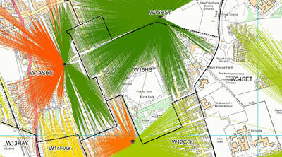
Understanding residents is a vital element of improved and more efficient service delivery for all councils.

Working in partnership to manage Britain's address and street infrastructure GeoPlace has published its 2014 Annual Statement The Statement contains a number ...

The Joint Emergency Services Group in Wales, supported by Welsh Government, UK Cabinet Office and Welsh Unitary Authorities have developed a mechanism to electr...
Boundary changes and the introduction of the Individual Elector Registration initiative in 2014 led to significant changes in how the elections function was sup...