

The Unique Property Reference Number (UPRN) is the unique identifier for every addressable location in the UK.
Unique Property Reference Numbers (UPRNs) and Unique Street Reference Numbers (USRNs) are now openly available and royalty-free for use on Open Government Licence (OGL) terms from Ordnance Survey.
Make confident decisions with UPRN address data
This Ordnance Survey video explains what UPRNs are, and their central importance in decision making.
Unique Property Reference Number (UPRN) – simple but powerful
The Unique Property Reference Number (UPRN) is the unique identifier for every addressable location across the UK.
An addressable location may be any kind of building, or it may be an object that might not have a ‘normal' address – such as a bus shelter or an electricity substation for example. UPRNs provide every property (or object) with a consistent identifier throughout its lifecycle, from planning through to demolition.
Who allocates Unique Property Reference Number (UPRN)?
UPRNs are allocated by local authorities and by Ordnance Survey (OS) from a range provided by GeoPlace. Local authorities have statutory permission to name and number every street and property in Great Britain and also allocate UPRNs to other objects. OS identifies features in the landscape that might not have a ‘normal' address and includes them in its AddressBase products.
A central source for addresses and streets
GeoPlace is the central source for UK addresses and streets. We work contractually with all 339 councils in England and Wales which have statutory responsibility for approving and creating addresses and 174 local highways authorities.
We manage a central hub of 42.8 million addresses and 1.3 million streets, taking feeds of address and street data from local authorities in England and Wales, central government, Ordnance Survey, Royal Mail and data from Scotland, Northern Ireland, Isle of Man and the Channel Islands via the Improvement Service, Land & Property Services, Isle of Man Government and Digimap respectively.
Data from Northern Ireland is via Pointer, the address database for Northern Ireland. Land & Property Services (LPS) maintains the database with help from local councils and Royal Mail.
Find out more, and see the infographic that shows the processes that take place at GeoPlace here.
Why do we need Unique Property Reference Numbers (UPRN)?
Unique and authoritative, the UPRN is like a National Insurance number for physical objects. Everything in Great Britain can be identified with a UPRN.
This authoritative ‘code' can be used to create trusted connections between disparate sources of information sharing a common characteristic: location. Even if there are other issues with the datasets, the UPRN is a simple and unique reference point.
Crucially, when organisations add the UPRN to any kind of data, they can link matching records in different databases together. This means fewer errors in data exchange and communication, but far greater efficiency in all kinds of operations.
Many technologies can be used to share the UPRN, including spreadsheets, databases, XML/GML schema and linked data. Groups already using the UPRN include local and central government bodies, the emergency services, insurance providers, and utility companies.
What are the benefits of using UPRNs?
The Unique Property Reference Number (UPRN) is a unique identifier assigned to each addressable property in the United Kingdom. UPRNs offer several benefits that contribute to efficient data management, service delivery, and coordination. Here are some key advantages:
- Accurate property identification: UPRNs ensure a precise and standardised reference for identifying individual properties. This helps eliminate ambiguity and confusion, ensuring accurate identification and differentiation of properties, even within complex or large developments
- Improved data integration and sharing: UPRNs facilitate the integration and sharing of property-related data across different systems and organizations. This enables seamless data exchange between local authorities, central government, emergency services, utility providers, and the private sector, leading to better coordination and service delivery
- Enhanced address accuracy and consistency: With UPRNs, address databases and systems can maintain consistent and up-to-date records of properties. This reduces errors and discrepancies in address information, benefiting various sectors such as health and social care, insurance and underwriting, and property management
- Efficient service provision: UPRNs enable service providers to locate and identify properties more efficiently, leading to improved service provision. It helps streamline processes such as property maintenance, waste management, utility connections, and service delivery, resulting in cost savings and enhanced customer satisfaction
- Spatial planning and analysis: UPRNs support spatial planning and analysis by providing a consistent identifier for properties. It enables better understanding of property distribution, land use patterns, infrastructure needs, and development planning. This information aids in decision-making, policy formulation, and resource allocation at local and national levels
- Data-driven insights and research: UPRNs facilitate the analysis of property-related data for research purposes. Researchers and analysts can leverage the unique identifiers to study housing trends, demographic patterns, socioeconomic factors, and other aspects related to property and planning
Overall, Unique Property Reference Numbers provide a standardized and accurate means of identifying and referencing properties. They support efficient data management, coordination of services, accurate addressing, and informed decision-making in various sectors, leading to improved service delivery, better resource allocation, and effective spatial planning.
How is the Unique Property Reference Number (UPRN) evolving?
Under the Public Sector Mapping Agreement, every organisation in the public sector can use UPRNs on a royalty-free and open basis.
For example, the data is being used for emergency response by the emergency services; by HM Revenue and Customs to collect taxes; by Department of Work and Pensions to pay benefits, and by the Environment Agency to produce flood plans.
This means immense savings are possible – money, time, resources, and lives.
The entire public sector has access to the address information created and maintained by local authorities through the AddressBase® range of products and made available by Ordnance Survey.
On the 2nd of April 2020, the Government announced that the Unique Property Reference Number (UPRN) and Unique Street Reference Number (USRN) will be released under Open Government Licence. Additionally, the Open Standards Board, via Government Digital Service (GDS), has mandated that from 1st July 2020, the UPRN and USRN are the public sector standard for referencing and sharing property and street information. Find out more.
How do I get hold of Unique Property Reference Numbers (UPRNs)?
UPRNs are available to the market as part of OS AddressBase®, a portfolio of data products that’s been jointly created by GeoPlace and Ordnance Survey (OS).
As the national mapping service, OS is responsible for providing, promoting, marketing and licensing AddressBase®. The AddressBase® portfolio comprises a family of related but distinct products.
AddressBase® Premium is the flagship addressing product. It provides:
- a UPRN for every addressable location
- every authoritative local authority geospatial address
- Royal Mail postcodes and post town names (where matched to a UPRN)
- addresses with sub-divisions or multiple occupants
- objects without postal addresses such as bus shelters or named ponds
- cross-references to VOA data and OS MasterMap® Topography and Highways Network
- street identifiers (Unique Street Reference Numbers (USRNs)
- coordinates
- classification for each address
A new AddressBase® product, AddressBase® Core, was added to OS’s addressing portfolio in July 2020. It is simplified, easy to use data product providing all ‘live’ addresses with a weekly update frequency. It offers a single line address and simplified attribute structure, with cross-references to PAF and OS MasterMap®. Classification of addresses is provided at both a primary and secondary level.
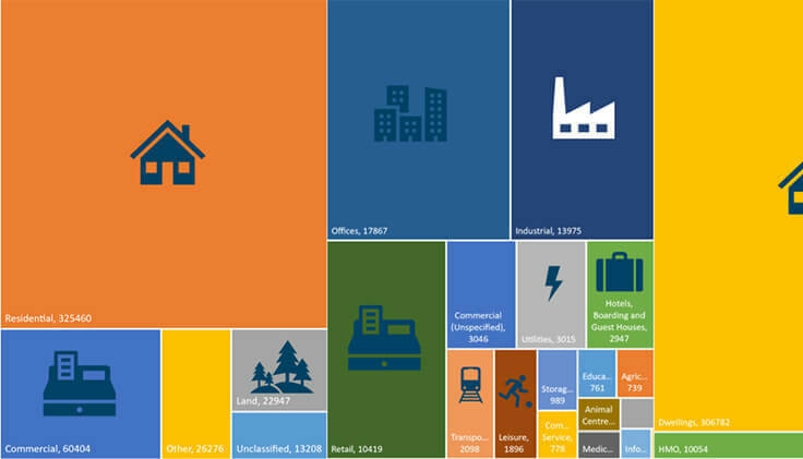
The growth in the number of UPRNs in the last 25 years:
Take-up and use of UPRNs have grown exponentially in the last 25 years. There are now over 42.8 million UPRNs in use across the UK today.
From planning to maintenance to demolition
A session at the 2022 GeoPlace annual conference looked at the lifecycle of the UPRN, and the many different processes and organisations involved.
You must use UPRNs and USRNs
Central Government mandates the use of the UPRN and USRN to reference addresses and streets
UPRNs and the property lifecycle
Widespread adoption of UPRNs creates ease and simplicity, making it possible to fetch whole datasets with just one click and gain data insight against one single asset.
A common standard for digital transformation
Scalable examples demonstrating how address and street data can be used by councils
The value of data
ROI of address and street data
A Return on Investment analysis assessing the value of address and street data to local authorities in England and Wales, 2022

2021 - 2022
What's changed in England and Wales in the last year?
Our spatial analysis team here at GeoPlace has undertaken a review of new data and changes to existing data within AddressBase between April 2021 and March 2022. Find out what the report said.
open UPRNs and USRNs
The power of place
From July 2020, Unique Property Reference Numbers (UPRNs) and Unique Street Reference Numbers (USRNs) are openly available and royalty free for use on Open Government Licence (OGL) terms from Ordnance Survey.

UPRN and USRN
Linked data using the UPRN and USRN
Take a look at some datasets that have been linked to the UPRN or USRN by various organisations.

2019 conference case studies
Bringing location to life
Find out more about Bringing location to life View more about Bringing location to life
2018 conference case studies
Linking people to places
Find out more about Linking people to places View more about Linking people to places
2017 conference case studies
Connecting data for better outcomes
Find out more about Connecting data for better outcomes View more about Connecting data for better outcomes